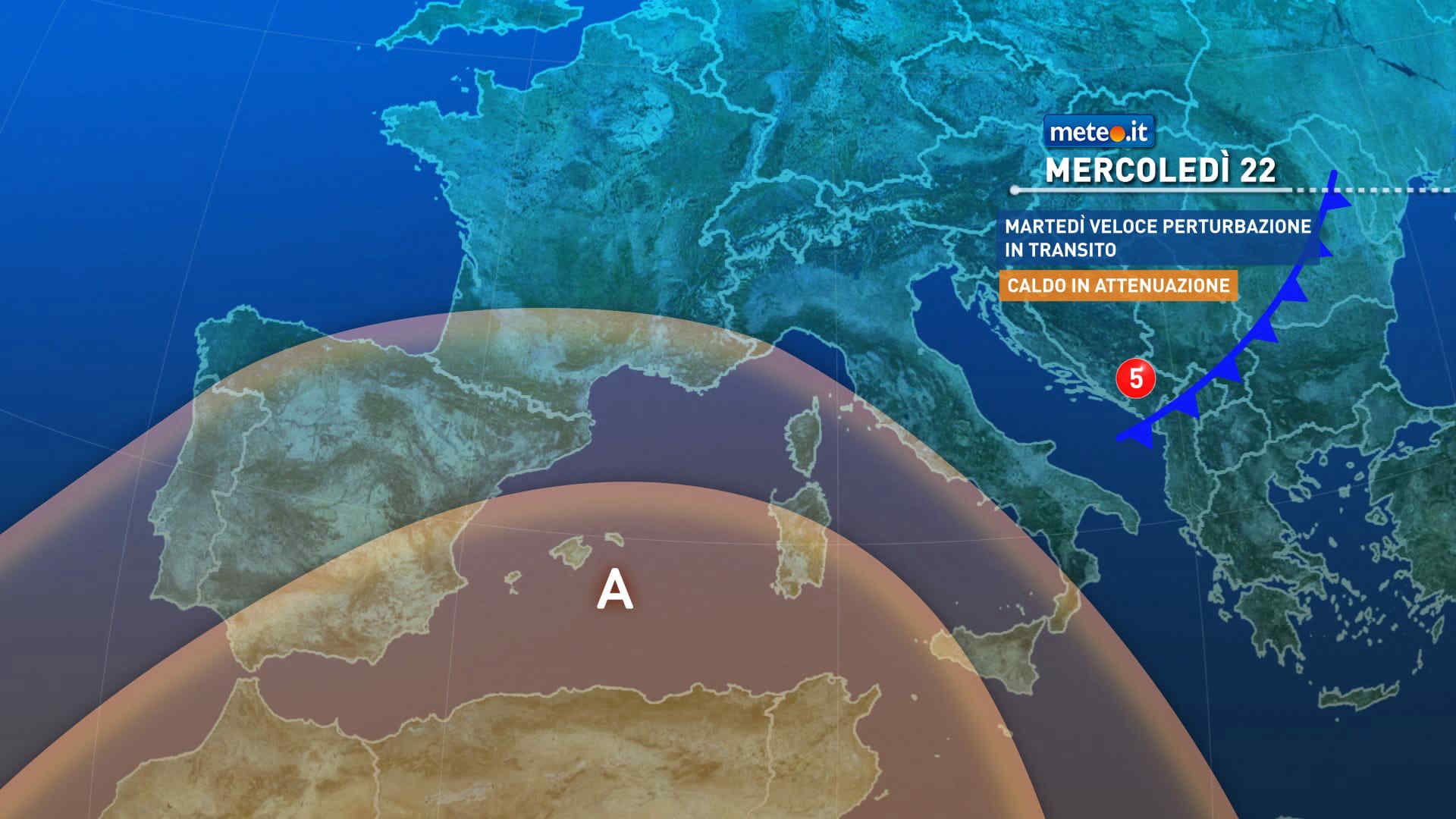
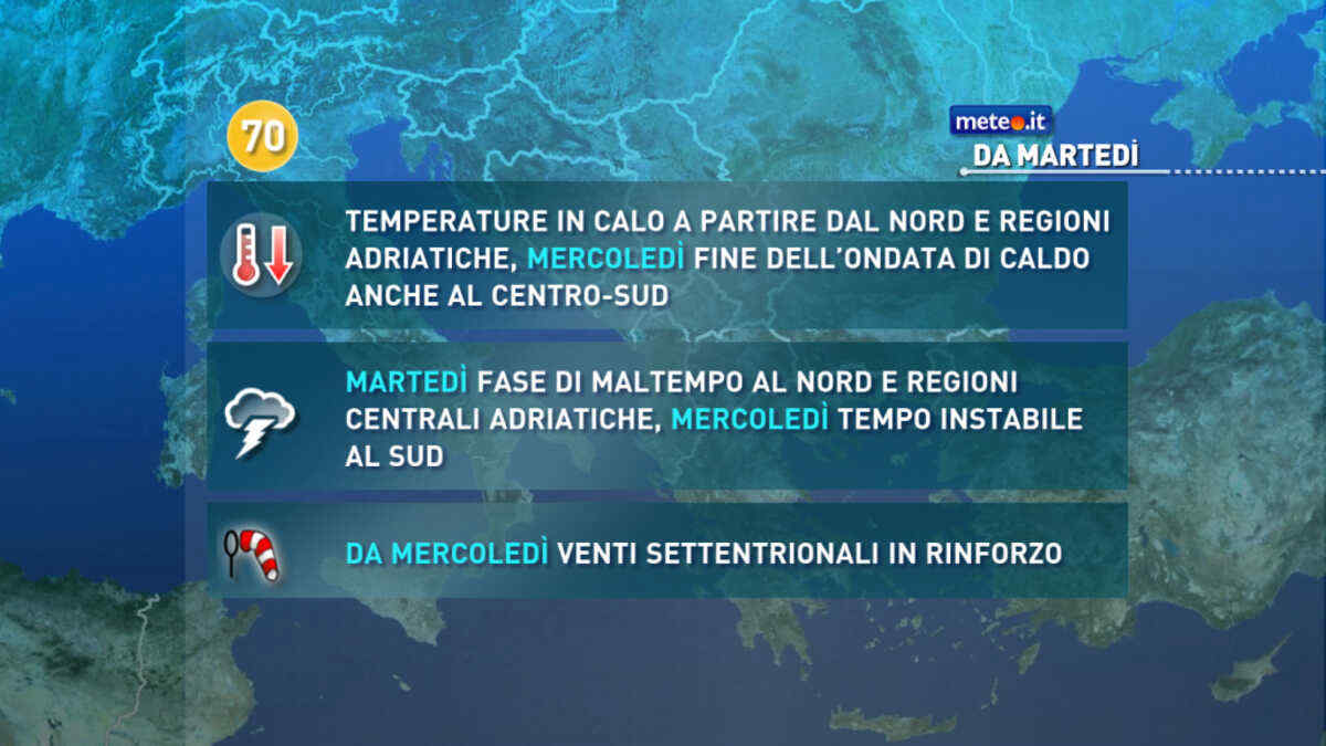
FacebookInstagramTwitterWhatsApp

Meteo Santa Maria di Sala tra 3 giorni. Previsioni del tempo, precipitazioni, temperatura e venti

FacebookWhatsappTwitterTelegram

Santa Maria di Sala
06:02
20:16
Gibbosa calante
Notte
sereno notte
Mattino
soleggiato
Pomeriggio
soleggiato
Sera
sereno notte
  • 14°

    UV Normale 0

    ore

    sereno notte

    Umidità alta79%

    Raffiche normali6-14 Km/h

    Est sud estEst SE

  • 13°

    UV Normale 0

    ore

    sereno notte

    Umidità alta81%

    Raffiche normali6-14 Km/h

    EstEst

  • 13°

    UV Normale 0

    ore

    sereno notte

    Umidità alta82%

    Raffiche normali6-14 Km/h

    EstEst

  • 12°

    UV Normale 0

    ore

    sereno notte

    Umidità alta84%

    Raffiche normali6-14 Km/h

    Est nord estEst NE

  • 11°

    UV Normale 0

    ore

    sereno notte

    Umidità alta85%

    Raffiche normali6-14 Km/h

    Nord estNord E

  • 11°

    UV Normale 0

    ore

    sereno notte

    Umidità alta87%

    Raffiche normali5-13 Km/h

    Nord nord estNord NE

  • 10°

    UV Normale 1

    ore

    soleggiato

    Umidità alta88%

    Raffiche normali5-12 Km/h

    NordNord

  • 12°

    UV Normale 2

    ore

    soleggiato

    Umidità alta82%

    Raffiche normali5-12 Km/h

    Nord nord ovestNord NO

  • 13°

    UV Normale 3

    ore

    soleggiato

    Umidità alta76%

    Raffiche normali5-11 Km/h

    Nord ovestNord O

  • 15°

    UV Normale 4

    ore

    soleggiato

    Umidità normale70%

    Raffiche normali5-11 Km/h

    OvestOvest

  • 16°

    UV Elevato 6

    ore

    soleggiato

    Umidità normale65%

    Raffiche normali5-12 Km/h

    Ovest nord ovestOvest NO

  • 18°

    UV Elevato 7

    ore

    soleggiato

    Umidità normale61%

    Raffiche normali6-12 Km/h

    Nord ovestNord O

  • 19°

    UV Elevato 8

    ore

    soleggiato

    Umidità normale56%

    Raffiche normali7-13 Km/h

    NordNord

  • 21°

    UV Elevato 9

    ore

    soleggiato

    Umidità normale51%

    Raffiche normali7-14 Km/h

    Nord nord estNord NE

  • 22°

    UV Elevato 8

    ore

    soleggiato

    Umidità normale46%

    Raffiche normali8-15 Km/h

    Nord estNord E

  • 24°

    UV Elevato 7

    ore

    soleggiato

    Umidità normale42%

    Raffiche normali9-16 Km/h

    EstEst

  • 25°

    UV Elevato 6

    ore

    soleggiato

    Umidità normale37%

    Raffiche normali9-16 Km/h

    EstEst

  • 24°

    UV Normale 4

    ore

    soleggiato

    Umidità normale41%

    Raffiche normali8-17 Km/h

    Est sud estEst SE

  • 22°

    UV Normale 3

    ore

    soleggiato

    Umidità normale45%

    Raffiche normali8-17 Km/h

    Est sud estEst SE

  • 21°

    UV Normale 2

    ore

    soleggiato

    Umidità normale48%

    Raffiche normali8-18 Km/h

    Sud estSud E

  • 19°

    UV Normale 1

    ore

    soleggiato

    Umidità normale52%

    Raffiche normali8-18 Km/h

    Sud estSud E

  • 18°

    UV Normale 0

    ore

    sereno notte

    Umidità normale56%

    Raffiche forti8-19 Km/h

    Sud sud est intensoSud SE

  • 17°

    UV Normale 0

    ore

    sereno notte

    Umidità normale58%

    Raffiche forti8-19 Km/h

    Sud est intensoSud E

  • 17°

    UV Normale 0

    ore

    sereno notte

    Umidità normale60%

    Raffiche forti8-19 Km/h

    Est sud est intensoEst SE

  • 16°

    UV Normale 0

    ore

    sereno notte

    Umidità normale61%

    Raffiche forti7-19 Km/h

    Est intensoEst

Meteo provincia di Venezia
Meteo Nord-Est Italia
Oggi

Al mattino cielo in prevalenza nuvoloso, salvo residue schiarite lungo la costa veneta. Temperature minime in leggero rialzo. Nel pomeriggio cielo nuvoloso. Brevi rovesci isolati saranno piu' probabili sull'Emilia Romagna; deboli precipitazioni isolate su Alpi e Prealpi, nevose sopra 1500-1600. Temperature massime in lieve aumento. Venti in prevalenza deboli. Mare adriatico da poco mosso a localmente mosso.

Notizie
TendenzaMeteo, dal 28 aprile picchi oltre 25 gradi: ecco dove
Meteo, dal 28 aprile picchi oltre 25 gradi: ecco dove
Temperature in netto aumento: si torna sopra le medie soprattutto al Centro-sud e sulle Isole dove potremo superare i 25 gradi. La tendenza meteo
Mediaset

Ultimo aggiornamento Venerdì 26 Aprile ore 00:43

Copyright © 1999-2020 RTI S.p.A. Direzione Business Digital - P.Iva 03976881007 - Tutti i diritti riservati - Per la pubblicità Mediamond S.p.a. RTI spa, Gruppo Mediaset - Sede legale: 00187 Roma Largo del Nazareno 8 - Cap. Soc. € 500.000.007,00 int. vers. - Registro delle Imprese di Roma, C.F.06921720154