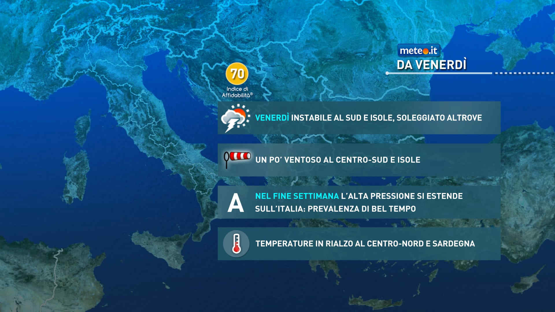
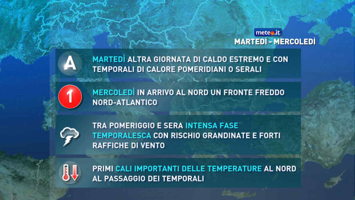
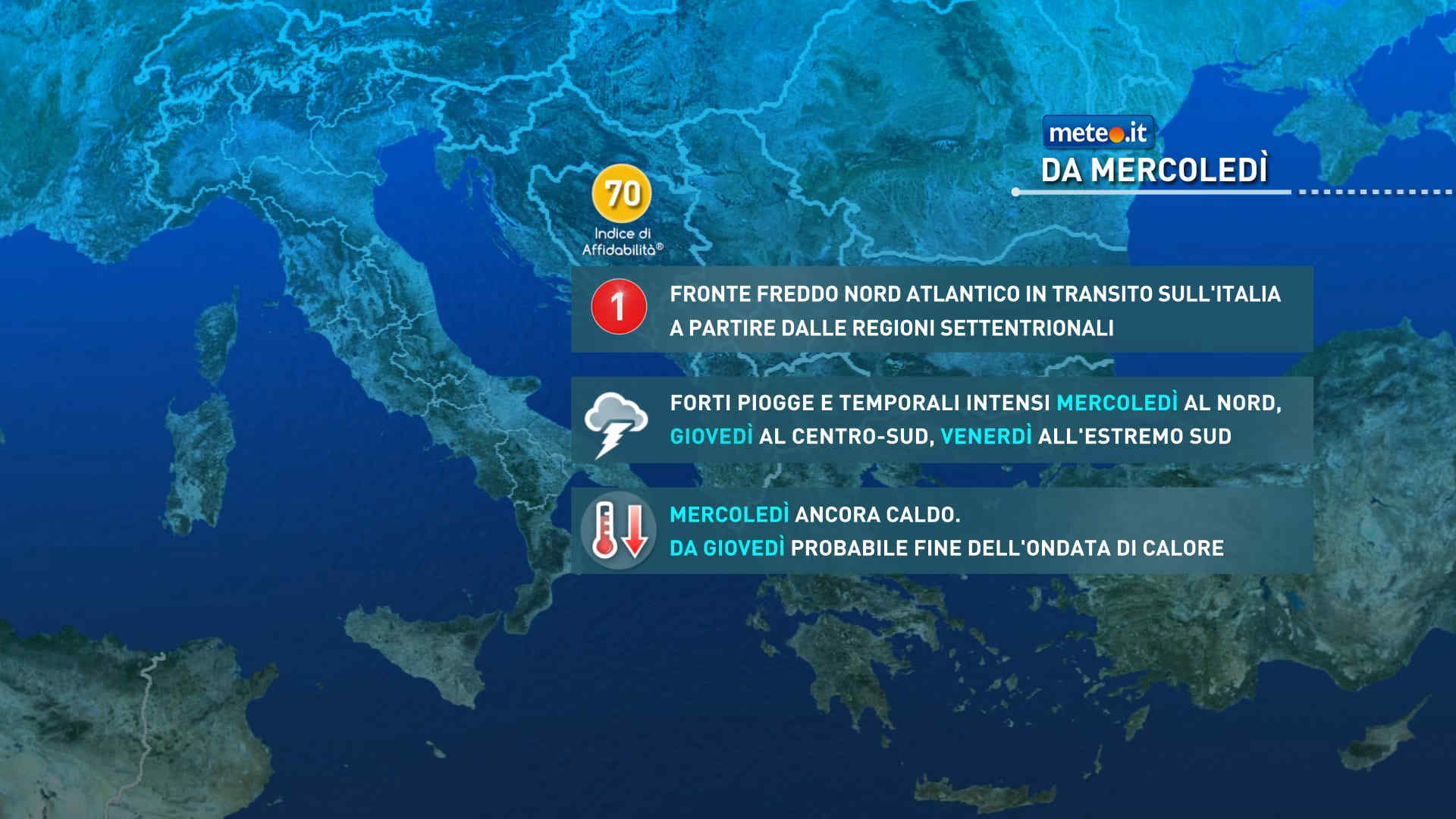
FacebookInstagramTwitterWhatsApp

Meteo Verderio Superiore tra 8 giorni. Previsioni del tempo, precipitazioni, temperatura e venti

FacebookWhatsappTwitterTelegram

Verderio Superiore
Notte
sereno notte
Mattino
soleggiato
Pomeriggio
soleggiato
Sera
sereno notte
  • 18°

    UV Normale 0

    ore

    poco nuvoloso

    Umidità normale51%

    Raffiche forti11-21 Km/h

    Nord est intensoNord E

  • 17°

    UV Normale 0

    ore

    poco nuvoloso

    Umidità normale52%

    Raffiche forti11-21 Km/h

    Nord est intensoNord E

  • 17°

    UV Normale 0

    ore

    sereno notte

    Umidità normale54%

    Raffiche forti11-22 Km/h

    Nord est intensoNord E

  • 16°

    UV Normale 0

    ore

    sereno notte

    Umidità normale55%

    Raffiche forti11-22 Km/h

    Nord est intensoNord E

  • 15°

    UV Normale 0

    ore

    sereno notte

    Umidità normale56%

    Raffiche forti10-21 Km/h

    Nord est intensoNord E

  • 15°

    UV Normale 0

    ore

    sereno notte

    Umidità normale58%

    Raffiche forti9-20 Km/h

    Nord est intensoNord E

  • 14°

    UV Normale 1

    ore

    soleggiato

    Umidità normale59%

    Raffiche forti9-19 Km/h

    Nord est intensoNord E

  • 15°

    UV Normale 2

    ore

    soleggiato

    Umidità normale55%

    Raffiche normali8-18 Km/h

    Nord estNord E

  • 17°

    UV Normale 3

    ore

    soleggiato

    Umidità normale51%

    Raffiche normali8-17 Km/h

    Nord estNord E

  • 18°

    UV Normale 4

    ore

    soleggiato

    Umidità normale47%

    Raffiche normali7-16 Km/h

    Est nord estEst NE

  • 19°

    UV Elevato 6

    ore

    soleggiato

    Umidità normale44%

    Raffiche normali7-16 Km/h

    Est nord estEst NE

  • 20°

    UV Elevato 7

    ore

    soleggiato

    Umidità normale42%

    Raffiche normali8-16 Km/h

    Est nord estEst NE

  • 21°

    UV Elevato 8

    ore

    soleggiato

    Umidità normale39%

    Raffiche normali8-16 Km/h

    EstEst

  • 23°

    UV Elevato 9

    ore

    soleggiato

    Umidità normale37%

    Raffiche normali9-15 Km/h

    Est sud estEst SE

  • 24°

    UV Elevato 8

    ore

    soleggiato

    Umidità normale34%

    Raffiche normali9-15 Km/h

    Est sud estEst SE

  • 25°

    UV Elevato 7

    ore

    soleggiato

    Umidità normale32%

    Raffiche normali10-15 Km/h

    Sud estSud E

  • 26°

    UV Elevato 6

    ore

    soleggiato

    Umidità normale29%

    Raffiche normali10-16 Km/h

    Sud estSud E

  • 25°

    UV Normale 4

    ore

    soleggiato

    Umidità normale32%

    Raffiche normali11-17 Km/h

    Est sud estEst SE

  • 24°

    UV Normale 3

    ore

    soleggiato

    Umidità normale35%

    Raffiche forti12-19 Km/h

    Est intensoEst

  • 22°

    UV Normale 2

    ore

    soleggiato

    Umidità normale38%

    Raffiche forti13-20 Km/h

    Est nord est intensoEst NE

  • 21°

    UV Normale 1

    ore

    soleggiato

    Umidità normale41%

    Raffiche forti13-21 Km/h

    Est nord est intensoEst NE

  • 20°

    UV Normale 0

    ore

    sereno notte

    Umidità normale44%

    Raffiche forti14-23 Km/h

    Nord est intensoNord E

  • 20°

    UV Normale 0

    ore

    sereno notte

    Umidità normale46%

    Raffiche forti14-22 Km/h

    Nord est intensoNord E

  • 19°

    UV Normale 0

    ore

    sereno notte

    Umidità normale47%

    Raffiche forti14-22 Km/h

    Nord est intensoNord E

  • 19°

    UV Normale 0

    ore

    sereno notte

    Umidità normale48%

    Raffiche forti13-22 Km/h

    Nord est intensoNord E

Meteo provincia di Lecco
Meteo Nord-Ovest Italia
Oggi

Al mattino cielo molto nuvoloso o coperto con precipitazioni sparse in Lombardia, Piemonte orientale e meridionale e Appennino Ligure. Limite delle nevicate intorno ai 600-800 metri. Temperature minime in lieve calo. Nel pomeriggio ancora nuvoloso ovunque. Possibili piogge intermittenti in Lombardia, alto Piemonte e Ponente ligure; neve su Alpi lombarde e occidentali e Appennino Ligure oltre 800-1100 metri. Miglioramento in serata. Temperature massime in rialzo, ma sempre sotto la media. Un po' ventoso per venti settentrionali, specie in Liguria. Mar Ligure poco mosso sotto costa, mosso al largo.

Notizie
TendenzaMeteo: ponte del 25 aprile molto variabile. Quando andrà via il freddo artico?
Meteo: ponte del 25 aprile molto variabile. Quando andrà via il freddo artico?
Colpo di coda invernale sull'Italia dove nella seconda parte di settimana si potrebbe vedere un graduale cambiamento. Ponte del 25 aprile incerto
Mediaset

Ultimo aggiornamento Martedì 23 Aprile ore 08:49

Copyright © 1999-2020 RTI S.p.A. Direzione Business Digital - P.Iva 03976881007 - Tutti i diritti riservati - Per la pubblicità Mediamond S.p.a. RTI spa, Gruppo Mediaset - Sede legale: 00187 Roma Largo del Nazareno 8 - Cap. Soc. € 500.000.007,00 int. vers. - Registro delle Imprese di Roma, C.F.06921720154