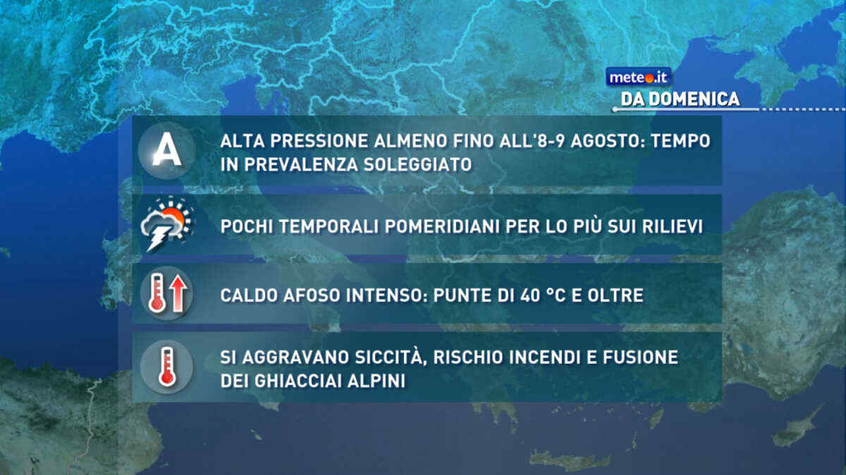
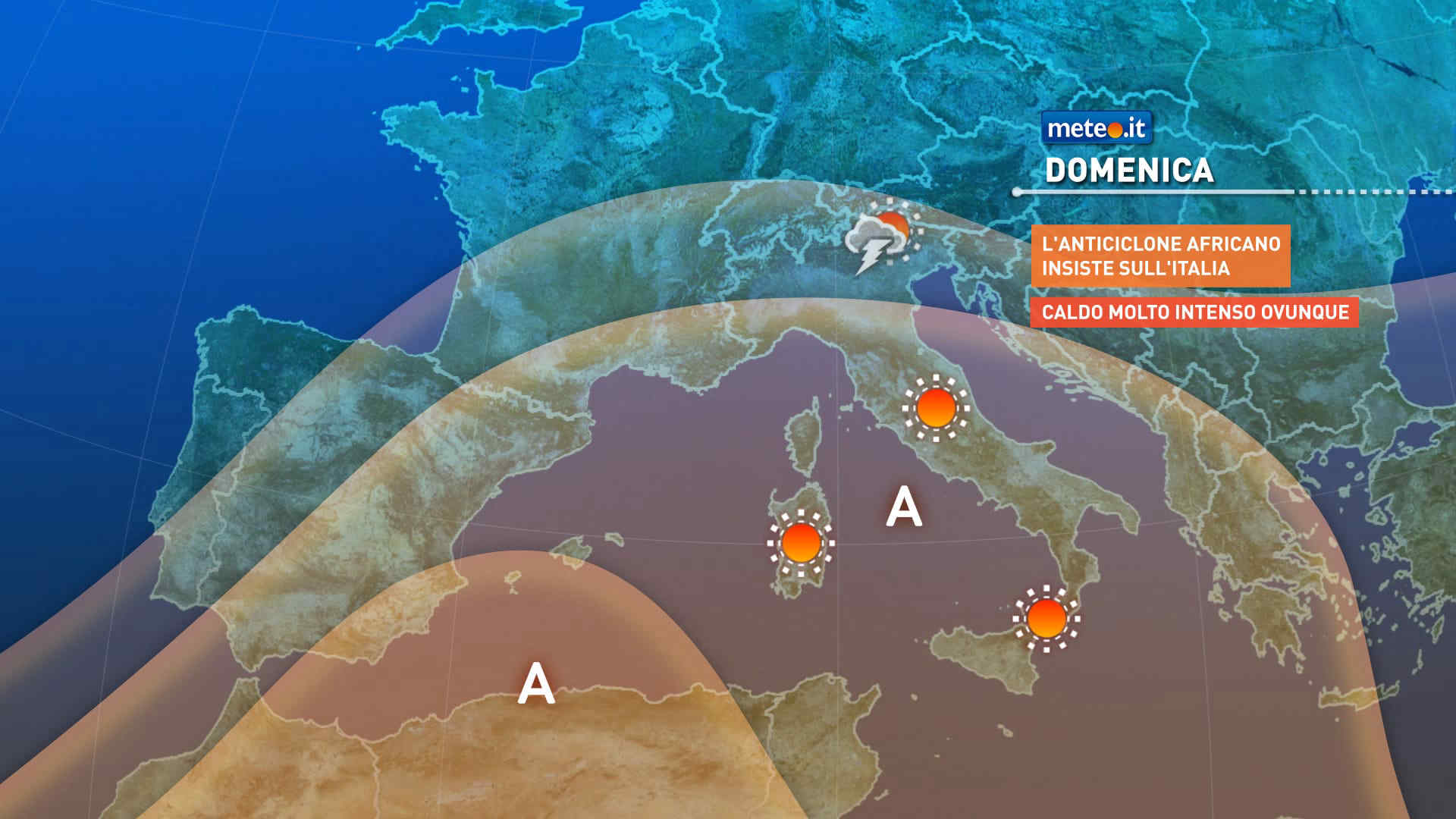
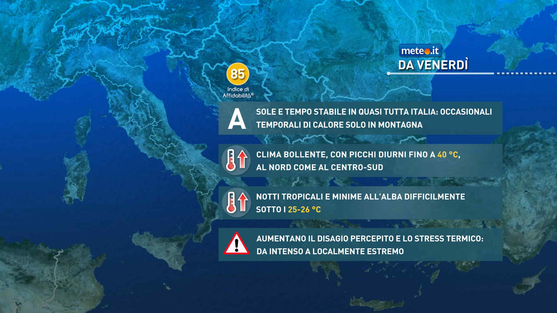
FacebookInstagramTwitterWhatsApp

Meteo Piario tra 7 giorni. Previsioni del tempo, precipitazioni, temperatura e venti

FacebookWhatsappTwitterTelegram

Piario
07:55
16:36
Luna crescente
Notte
poco nuvoloso
Mattino
soleggiato
Pomeriggio
soleggiato
Sera
sereno notte
  • UV Normale 0

    ore

    cielo in gran parte nuvoloso

    Umidità alta90%

    Raffiche normali2-7 Km/h

    Nord ovestNord O

  • UV Normale 0

    ore

    poco nuvoloso

    Umidità alta89%

    Raffiche normali1-6 Km/h

    Nord ovestNord O

  • UV Normale 0

    ore

    poco nuvoloso

    Umidità alta88%

    Raffiche normali1-4 Km/h

    Nord nord ovestNord NO

  • UV Normale 0

    ore

    poco nuvoloso

    Umidità alta87%

    Raffiche normali0-3 Km/h

    NordNord

  • UV Normale 0

    ore

    poco nuvoloso

    Umidità alta86%

    Raffiche normali0-3 Km/h

    NordNord

  • UV Normale 0

    ore

    poco nuvoloso

    Umidità alta86%

    Raffiche normali0-3 Km/h

    Nord nord ovestNord NO

  • UV Normale 0

    ore

    poco nuvoloso

    Umidità alta85%

    Raffiche normali0-3 Km/h

    Nord nord ovestNord NO

  • UV Normale 1

    ore

    soleggiato

    Umidità alta84%

    Raffiche normali0-3 Km/h

    Nord ovestNord O

  • UV Normale 1

    ore

    soleggiato

    Umidità alta83%

    Raffiche normali0-3 Km/h

    Nord ovestNord O

  • UV Normale 2

    ore

    soleggiato

    Umidità alta82%

    Raffiche normali0-3 Km/h

    Ovest nord ovestOvest NO

  • UV Normale 2

    ore

    soleggiato

    Umidità alta81%

    Raffiche normali1-4 Km/h

    Ovest nord ovestOvest NO

  • UV Normale 2

    ore

    soleggiato

    Umidità alta80%

    Raffiche normali2-5 Km/h

    Ovest nord ovestOvest NO

  • UV Normale 3

    ore

    soleggiato

    Umidità alta79%

    Raffiche normali3-6 Km/h

    OvestOvest

  • UV Normale 3

    ore

    soleggiato

    Umidità alta78%

    Raffiche normali4-8 Km/h

    Ovest sud ovestOvest SO

  • UV Normale 2

    ore

    soleggiato

    Umidità alta77%

    Raffiche normali5-9 Km/h

    Ovest sud ovestOvest SO

  • UV Normale 2

    ore

    soleggiato

    Umidità alta76%

    Raffiche normali6-10 Km/h

    Sud ovestSud O

  • UV Normale 1

    ore

    soleggiato

    Umidità alta76%

    Raffiche normali5-9 Km/h

    Sud ovestSud O

  • UV Normale 0

    ore

    sereno notte

    Umidità alta76%

    Raffiche normali4-7 Km/h

    Sud ovestSud O

  • UV Normale 0

    ore

    sereno notte

    Umidità alta76%

    Raffiche normali3-6 Km/h

    Ovest sud ovestOvest SO

  • UV Normale 0

    ore

    sereno notte

    Umidità alta76%

    Raffiche normali2-5 Km/h

    Ovest sud ovestOvest SO

  • UV Normale 0

    ore

    sereno notte

    Umidità alta76%

    Raffiche normali1-4 Km/h

    OvestOvest

  • UV Normale 0

    ore

    sereno notte

    Umidità alta76%

    Raffiche normali0-2 Km/h

    OvestOvest

  • UV Normale 0

    ore

    sereno notte

    Umidità alta74%

    Raffiche normali1-3 Km/h

    Ovest nord ovestOvest NO

  • UV Normale 0

    ore

    sereno notte

    Umidità alta72%

    Raffiche normali1-4 Km/h

    Ovest nord ovestOvest NO

  • UV Normale 0

    ore

    sereno notte

    Umidità alta71%

    Raffiche normali1-5 Km/h

    Nord nord ovestNord NO

Meteo provincia di Bergamo
Meteo Nord-Ovest Italia
Oggi

Al mattino cielo molto nuvoloso o coperto in pianura con presenza di foschie o banchi di nebbia. Ampie schiarite sulle aree montuose alpine e prealpine e in Liguria. Temperature minime intorno allo zero. Nel pomeriggio cielo nuvoloso o molto nuvoloso con deboli nevicate oltre i 1200-1500 metri in Val d'Aosta e settori alpini di confine del Piemonte centro-settentrionale. In serata locali piogge tra Liguria di levante, Lombardia e Piemonte settentrionale. Neve anche moderata sulle Alpi ma a quote relativamente alte. Temperature massime in lieve aumento. Venti deboli. Mar ligure poco mosso.

Notizie
TendenzaMeteo, la prossima settimana inizierà con clima mite ma il freddo è alle porte
Meteo, la prossima settimana inizierà con clima mite ma il freddo è alle porte
Aria mite con temperature che tenderanno a rialzare in particolare al Centro-Sud con valori anche sopra le medie. Da venerdì 15 dicembre probabile fase più invernale
Mediaset

Ultimo aggiornamento Sabato 09 Dicembre ore 12:04

Copyright © 1999-2020 RTI S.p.A. Direzione Business Digital - P.Iva 03976881007 - Tutti i diritti riservati - Per la pubblicità Mediamond S.p.a. RTI spa, Gruppo Mediaset - Sede legale: 00187 Roma Largo del Nazareno 8 - Cap. Soc. € 500.000.007,00 int. vers. - Registro delle Imprese di Roma, C.F.06921720154