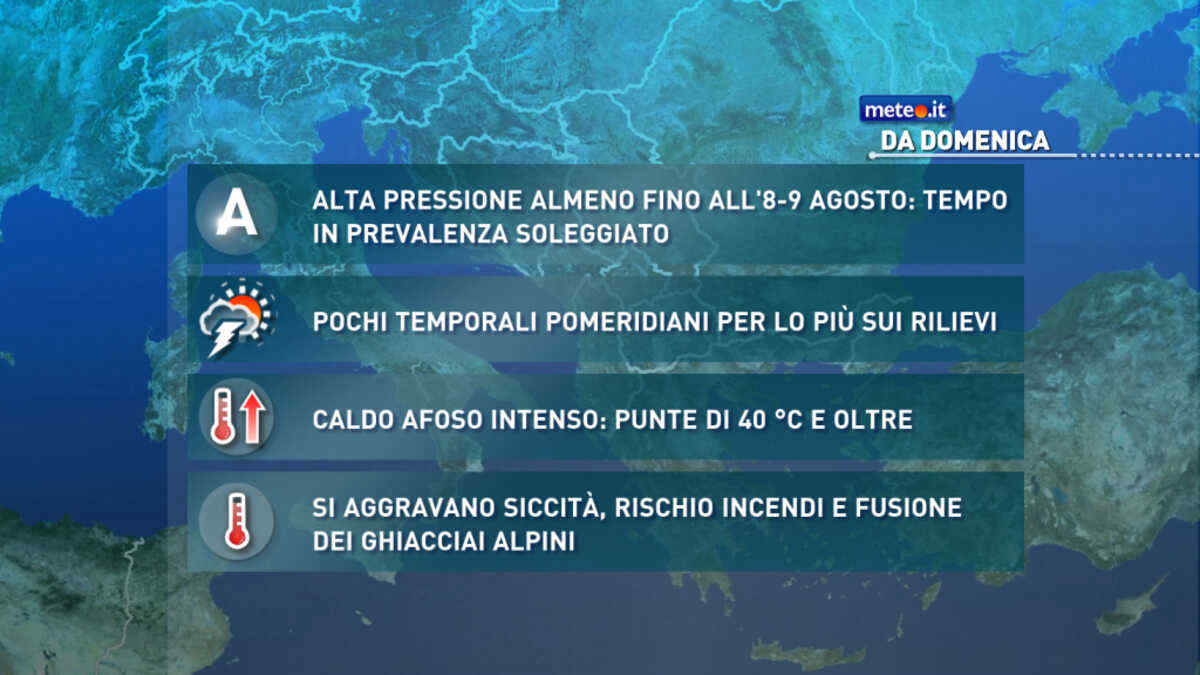
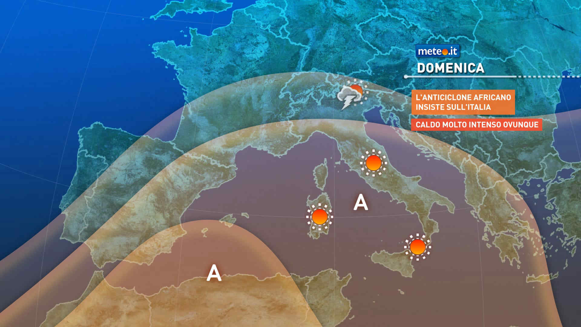
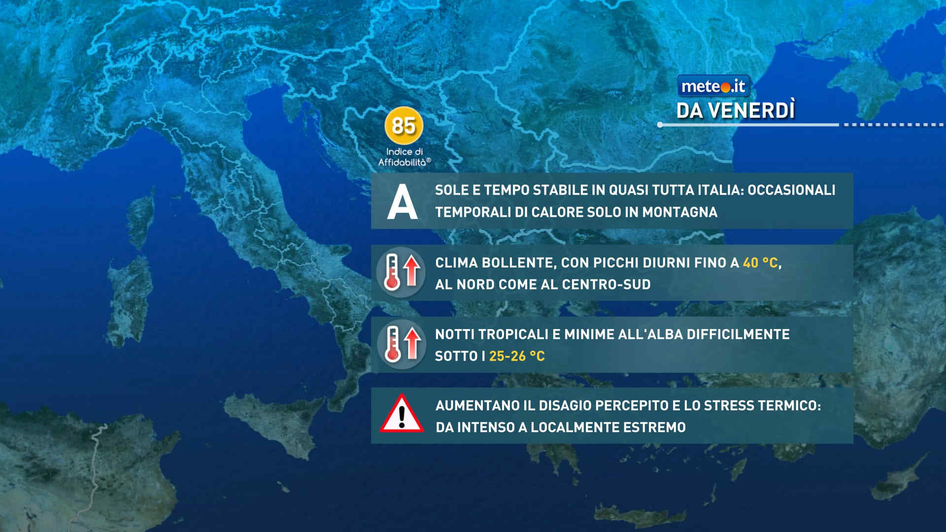
FacebookInstagramTwitterWhatsApp

Meteo Varano de' Melegari tra 7 giorni. Previsioni del tempo, precipitazioni, temperatura e venti

FacebookWhatsappTwitterTelegram

Varano de' Melegari
06:11
20:24
Gibbosa calante
Notte
poco nuvoloso
Mattino
prevalentemente soleggiato
Pomeriggio
soleggiato
Sera
sereno notte
  • 12°

    UV Normale 0

    ore

    poco nuvoloso

    Umidità normale62%

    Raffiche forti11-21 Km/h

    Ovest sud ovest intensoOvest SO

  • 11°

    UV Normale 0

    ore

    poco nuvoloso

    Umidità normale64%

    Raffiche forti11-21 Km/h

    Ovest sud ovest intensoOvest SO

  • 11°

    UV Normale 0

    ore

    poco nuvoloso

    Umidità normale67%

    Raffiche forti11-21 Km/h

    Ovest sud ovest intensoOvest SO

  • 10°

    UV Normale 0

    ore

    poco nuvoloso

    Umidità normale69%

    Raffiche forti10-21 Km/h

    Ovest sud ovest intensoOvest SO

  • 10°

    UV Normale 0

    ore

    poco nuvoloso

    Umidità alta71%

    Raffiche forti10-21 Km/h

    Ovest sud ovest intensoOvest SO

  • UV Normale 0

    ore

    poco nuvoloso

    Umidità alta73%

    Raffiche forti10-21 Km/h

    Ovest sud ovest intensoOvest SO

  • UV Normale 1

    ore

    prevalentemente soleggiato

    Umidità alta75%

    Raffiche forti9-20 Km/h

    Ovest sud ovest intensoOvest SO

  • 11°

    UV Normale 2

    ore

    prevalentemente soleggiato

    Umidità alta74%

    Raffiche forti9-20 Km/h

    Ovest sud ovest intensoOvest SO

  • 13°

    UV Normale 4

    ore

    prevalentemente soleggiato

    Umidità alta72%

    Raffiche forti9-20 Km/h

    Ovest sud ovest intensoOvest SO

  • 15°

    UV Normale 5

    ore

    prevalentemente soleggiato

    Umidità alta71%

    Raffiche forti8-20 Km/h

    Ovest sud ovest intensoOvest SO

  • 16°

    UV Elevato 6

    ore

    prevalentemente soleggiato

    Umidità normale67%

    Raffiche forti9-19 Km/h

    Ovest intensoOvest

  • 18°

    UV Elevato 7

    ore

    prevalentemente soleggiato

    Umidità normale63%

    Raffiche forti10-19 Km/h

    Ovest nord ovest intensoOvest NO

  • 19°

    UV Elevato 9

    ore

    prevalentemente soleggiato

    Umidità normale59%

    Raffiche normali11-18 Km/h

    Nord nord ovestNord NO

  • 20°

    UV Elevato 10

    ore

    prevalentemente soleggiato

    Umidità normale55%

    Raffiche normali11-18 Km/h

    Nord nord ovestNord NO

  • 21°

    UV Elevato 9

    ore

    soleggiato

    Umidità normale51%

    Raffiche normali12-17 Km/h

    NordNord

  • 23°

    UV Elevato 7

    ore

    soleggiato

    Umidità normale47%

    Raffiche normali13-17 Km/h

    Nord estNord E

  • 24°

    UV Elevato 6

    ore

    soleggiato

    Umidità normale43%

    Raffiche normali12-16 Km/h

    Nord estNord E

  • 22°

    UV Normale 5

    ore

    soleggiato

    Umidità normale45%

    Raffiche normali10-15 Km/h

    Nord estNord E

  • 21°

    UV Normale 4

    ore

    soleggiato

    Umidità normale47%

    Raffiche normali9-14 Km/h

    Nord nord estNord NE

  • 19°

    UV Normale 2

    ore

    soleggiato

    Umidità normale48%

    Raffiche normali8-13 Km/h

    Nord nord estNord NE

  • 18°

    UV Normale 1

    ore

    soleggiato

    Umidità normale50%

    Raffiche normali6-12 Km/h

    Nord nord estNord NE

  • 16°

    UV Normale 0

    ore

    sereno notte

    Umidità normale52%

    Raffiche normali5-11 Km/h

    Nord nord estNord NE

  • 15°

    UV Normale 0

    ore

    sereno notte

    Umidità normale55%

    Raffiche normali5-11 Km/h

    Nord nord estNord NE

  • 15°

    UV Normale 0

    ore

    sereno notte

    Umidità normale58%

    Raffiche normali5-12 Km/h

    NordNord

  • 14°

    UV Normale 0

    ore

    sereno notte

    Umidità normale60%

    Raffiche normali5-12 Km/h

    Nord nord ovestNord NO

Meteo provincia di Parma
Meteo Nord-Est Italia
Oggi

Al mattino cielo molto nuvoloso o coperto con precipitazioni sparse, meno probabili nell'Emilia Romagna orientale. Quota neve intorno a 600-800 metri. Temperature minime in calo. Nel pomeriggio ancora nuvoloso o molto nuvoloso, con precipitazioni sparse, anche a carattere di rovescio o temporale su Romagna e coste adriatiche; neve oltre 900-1000 metri di quota. Alla sera fenomeni in attenuazione. Temperature massime in calo in Romagna, quasi stazionarie altrove e sempre sotto la media. Leggermente ventilato. Mare adriatico poco mosso o mosso.

Notizie
TendenzaMeteo: ponte del 25 aprile molto variabile. Quando andrà via il freddo artico?
Meteo: ponte del 25 aprile molto variabile. Quando andrà via il freddo artico?
Colpo di coda invernale sull'Italia dove nella seconda parte di settimana si potrebbe vedere un graduale cambiamento. Ponte del 25 aprile incerto
Mediaset

Ultimo aggiornamento Martedì 23 Aprile ore 10:45

Copyright © 1999-2020 RTI S.p.A. Direzione Business Digital - P.Iva 03976881007 - Tutti i diritti riservati - Per la pubblicità Mediamond S.p.a. RTI spa, Gruppo Mediaset - Sede legale: 00187 Roma Largo del Nazareno 8 - Cap. Soc. € 500.000.007,00 int. vers. - Registro delle Imprese di Roma, C.F.06921720154