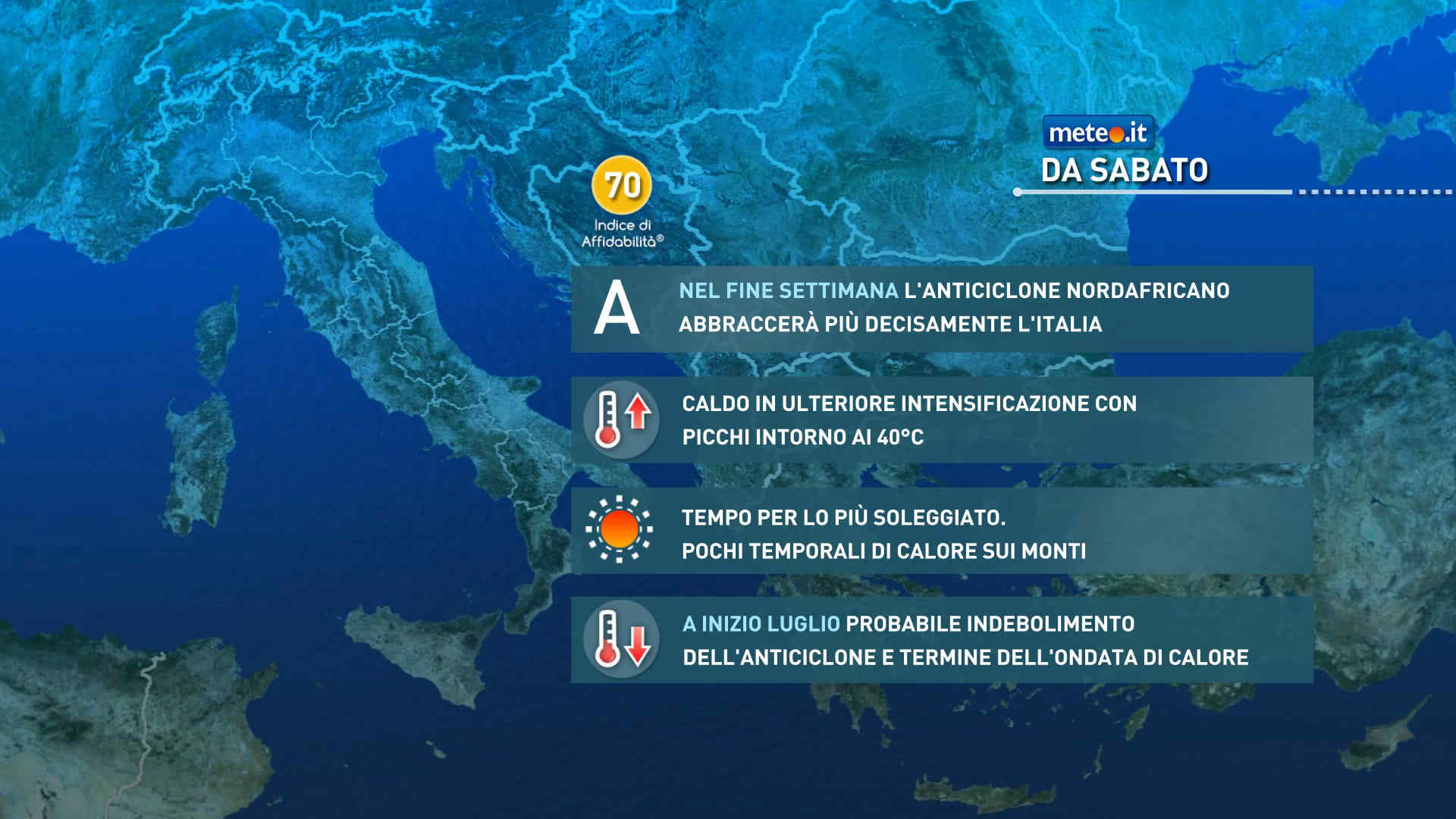
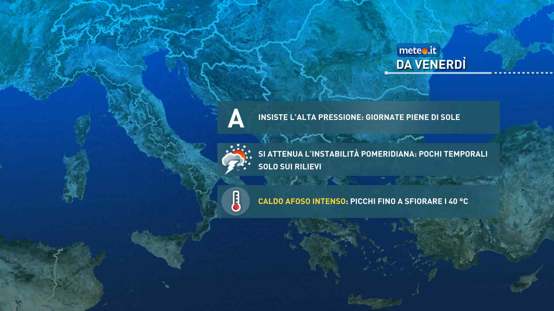
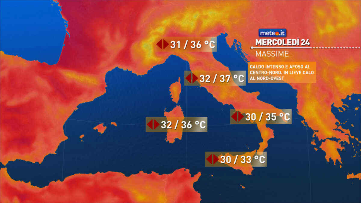
FacebookInstagramTwitterWhatsApp

Meteo San Giovanni Lupatoto tra 10 giorni. Previsioni del tempo, precipitazioni, temperatura e venti

FacebookWhatsappTwitterTelegram

San Giovanni Lupatoto
Vento alla sera
Notte
cielo coperto
Mattino
cielo in gran parte nuvoloso
Pomeriggio
prevalentemente soleggiato
Sera
poco nuvoloso
  • 15°

    UV Normale 0

    ore

    cielo in gran parte nuvoloso

    Umidità alta75%

    Raffiche forti29-48 Km/h

    Est nord est intensoEst NE

  • 15°

    UV Normale 0

    ore

    cielo in gran parte nuvoloso

    Umidità alta77%

    Raffiche forti27-46 Km/h

    Est nord est intensoEst NE

  • 14°

    UV Normale 0

    ore

    cielo coperto

    Umidità alta78%

    Raffiche forti26-45 Km/h

    Est nord est intensoEst NE

  • 14°

    UV Normale 0

    ore

    cielo coperto

    Umidità alta80%

    Raffiche forti24-43 Km/h

    Est nord est intensoEst NE

  • 14°

    UV Normale 0

    ore

    cielo coperto

    Umidità alta81%

    Raffiche forti21-39 Km/h

    Est nord est intensoEst NE

  • 13°

    UV Normale 0

    ore

    cielo coperto

    Umidità alta83%

    Raffiche forti19-35 Km/h

    Est nord est intensoEst NE

  • 13°

    UV Normale 1

    ore

    cielo coperto

    Umidità alta84%

    Raffiche forti16-31 Km/h

    Est intensoEst

  • 14°

    UV Normale 2

    ore

    cielo coperto

    Umidità alta82%

    Raffiche forti14-27 Km/h

    Est intensoEst

  • 15°

    UV Normale 3

    ore

    cielo in gran parte nuvoloso

    Umidità alta79%

    Raffiche forti11-23 Km/h

    Est intensoEst

  • 16°

    UV Normale 4

    ore

    cielo in gran parte nuvoloso

    Umidità alta77%

    Raffiche forti9-19 Km/h

    Est sud est intensoEst SE

  • 17°

    UV Elevato 6

    ore

    cielo in gran parte nuvoloso

    Umidità alta72%

    Raffiche forti10-20 Km/h

    Sud est intensoSud E

  • 18°

    UV Elevato 7

    ore

    cielo in gran parte nuvoloso

    Umidità normale67%

    Raffiche forti12-22 Km/h

    Sud sud est intensoSud SE

  • 19°

    UV Elevato 8

    ore

    cielo in gran parte nuvoloso

    Umidità normale62%

    Raffiche forti13-23 Km/h

    Sud intensoSud

  • 19°

    UV Elevato 9

    ore

    cielo in gran parte nuvoloso

    Umidità normale56%

    Raffiche forti15-24 Km/h

    Sud sud ovest intensoSud SO

  • 20°

    UV Elevato 8

    ore

    prevalentemente soleggiato

    Umidità normale51%

    Raffiche forti17-26 Km/h

    Sud sud ovest intensoSud SO

  • 21°

    UV Elevato 7

    ore

    prevalentemente soleggiato

    Umidità normale46%

    Raffiche forti18-27 Km/h

    Ovest sud ovest intensoOvest SO

  • 22°

    UV Elevato 6

    ore

    prevalentemente soleggiato

    Umidità normale41%

    Raffiche forti18-29 Km/h

    Ovest sud ovest intensoOvest SO

  • 21°

    UV Normale 4

    ore

    prevalentemente soleggiato

    Umidità normale45%

    Raffiche forti18-31 Km/h

    Ovest sud ovest intensoOvest SO

  • 20°

    UV Normale 3

    ore

    prevalentemente soleggiato

    Umidità normale49%

    Raffiche forti18-34 Km/h

    Ovest sud ovest intensoOvest SO

  • 19°

    UV Normale 2

    ore

    prevalentemente soleggiato

    Umidità normale53%

    Raffiche forti17-36 Km/h

    Ovest sud ovest intensoOvest SO

  • 18°

    UV Normale 1

    ore

    prevalentemente soleggiato

    Umidità normale57%

    Raffiche forti17-38 Km/h

    Ovest sud ovest intensoOvest SO

  • 17°

    UV Normale 0

    ore

    poco nuvoloso

    Umidità normale61%

    Raffiche forti17-40 Km/h

    Ovest sud ovest intensoOvest SO

  • 17°

    UV Normale 0

    ore

    poco nuvoloso

    Umidità normale63%

    Raffiche forti16-39 Km/h

    Ovest sud ovest intensoOvest SO

  • 16°

    UV Normale 0

    ore

    poco nuvoloso

    Umidità normale65%

    Raffiche forti16-38 Km/h

    Ovest intensoOvest

  • 11°

    UV Normale 0

    ore

    poco nuvoloso

    Umidità alta77%

    Raffiche forti14-32 Km/h

    Ovest intensoOvest

Meteo provincia di Verona
Meteo Nord-Est Italia
Oggi

Al mattino cielo sereno o poco nuvoloso con qualche annuvolamento piu' esteso in Romagna. Temperature minime stazionarie o in leggero calo. Nel pomeriggio un po' di nuvole in Trentino Alto Adige, specie nei settori di confine dove in serata saranno possibili delle nevicate oltre 1100 metri. Piu' soleggiato altrove con velature passeggere. Temperature massime in rialzo. Venti deboli. Mare poco mosso.

Notizie
TendenzaMeteo, ancora piogge e aria fredda nei prossimi giorni: la tendenza fino al 25 aprile
Meteo, ancora piogge e aria fredda nei prossimi giorni: la tendenza fino al 25 aprile
Via vai di perturbazioni e aria fredda: lo scenario meteo resta molto variabile almeno fino al 25 aprile. La tendenza e le zone a rischio pioggia
Mediaset

Ultimo aggiornamento Venerdì 19 Aprile ore 21:09

Copyright © 1999-2020 RTI S.p.A. Direzione Business Digital - P.Iva 03976881007 - Tutti i diritti riservati - Per la pubblicità Mediamond S.p.a. RTI spa, Gruppo Mediaset - Sede legale: 00187 Roma Largo del Nazareno 8 - Cap. Soc. € 500.000.007,00 int. vers. - Registro delle Imprese di Roma, C.F.06921720154