FacebookInstagramTwitterWhatsApp

Meteo Cingia de' Botti tra 10 giorni. Previsioni del tempo, precipitazioni, temperatura e venti

FacebookWhatsappTwitterTelegram

Cingia de' Botti
Notte
poco nuvoloso
Mattino
prevalentemente soleggiato
Pomeriggio
soleggiato
Sera
sereno notte
  • 17°

    UV Normale 0

    ore

    sereno notte

    Umidità normale64%

    Raffiche normali3-11 Km/h

    Est nord estEst NE

  • 16°

    UV Normale 0

    ore

    sereno notte

    Umidità normale70%

    Raffiche normali3-10 Km/h

    Nord estNord E

  • 14°

    UV Normale 0

    ore

    poco nuvoloso

    Umidità alta76%

    Raffiche normali3-10 Km/h

    Nord estNord E

  • 13°

    UV Normale 0

    ore

    poco nuvoloso

    Umidità alta82%

    Raffiche normali3-9 Km/h

    Nord nord estNord NE

  • 12°

    UV Normale 0

    ore

    poco nuvoloso

    Umidità alta87%

    Raffiche normali3-9 Km/h

    Nord nord estNord NE

  • 11°

    UV Normale 1

    ore

    prevalentemente soleggiato

    Umidità alta93%

    Raffiche normali4-10 Km/h

    Nord nord estNord NE

  • 12°

    UV Normale 2

    ore

    prevalentemente soleggiato

    Umidità alta91%

    Raffiche normali4-10 Km/h

    Nord estNord E

  • 13°

    UV Normale 3

    ore

    prevalentemente soleggiato

    Umidità alta90%

    Raffiche normali5-11 Km/h

    Nord estNord E

  • 13°

    UV Normale 4

    ore

    prevalentemente soleggiato

    Umidità alta88%

    Raffiche normali6-11 Km/h

    Nord estNord E

  • 14°

    UV Elevato 6

    ore

    prevalentemente soleggiato

    Umidità alta86%

    Raffiche normali6-11 Km/h

    Est nord estEst NE

  • 16°

    UV Elevato 7

    ore

    prevalentemente soleggiato

    Umidità alta79%

    Raffiche normali6-11 Km/h

    Est nord estEst NE

  • 17°

    UV Elevato 8

    ore

    prevalentemente soleggiato

    Umidità alta72%

    Raffiche normali5-10 Km/h

    Est nord estEst NE

  • 19°

    UV Elevato 9

    ore

    prevalentemente soleggiato

    Umidità normale65%

    Raffiche normali5-10 Km/h

    EstEst

  • 21°

    UV Elevato 10

    ore

    prevalentemente soleggiato

    Umidità normale57%

    Raffiche normali5-9 Km/h

    Est sud estEst SE

  • 23°

    UV Elevato 9

    ore

    soleggiato

    Umidità normale50%

    Raffiche normali4-8 Km/h

    Est sud estEst SE

  • 24°

    UV Elevato 7

    ore

    soleggiato

    Umidità normale43%

    Raffiche normali4-8 Km/h

    Sud estSud E

  • 26°

    UV Elevato 6

    ore

    soleggiato

    Umidità normale36%

    Raffiche normali4-11 Km/h

    Est sud estEst SE

  • 25°

    UV Normale 5

    ore

    soleggiato

    Umidità normale40%

    Raffiche normali5-14 Km/h

    Est sud estEst SE

  • 24°

    UV Normale 4

    ore

    soleggiato

    Umidità normale43%

    Raffiche normali5-17 Km/h

    Est sud estEst SE

  • 23°

    UV Normale 2

    ore

    soleggiato

    Umidità normale47%

    Raffiche forti6-20 Km/h

    Est sud est intensoEst SE

  • 22°

    UV Normale 1

    ore

    soleggiato

    Umidità normale50%

    Raffiche forti6-24 Km/h

    Est sud est intensoEst SE

  • 21°

    UV Normale 0

    ore

    sereno notte

    Umidità normale54%

    Raffiche forti7-27 Km/h

    Est sud est intensoEst SE

  • 20°

    UV Normale 0

    ore

    sereno notte

    Umidità normale59%

    Raffiche forti7-28 Km/h

    Est intensoEst

  • 19°

    UV Normale 0

    ore

    sereno notte

    Umidità normale64%

    Raffiche forti8-29 Km/h

    Est intensoEst

  • 12°

    UV Normale 0

    ore

    sereno notte

    Umidità alta94%

    Raffiche forti10-34 Km/h

    Est nord est intensoEst NE

Meteo provincia di Cremona
Meteo Nord-Ovest Italia
Oggi

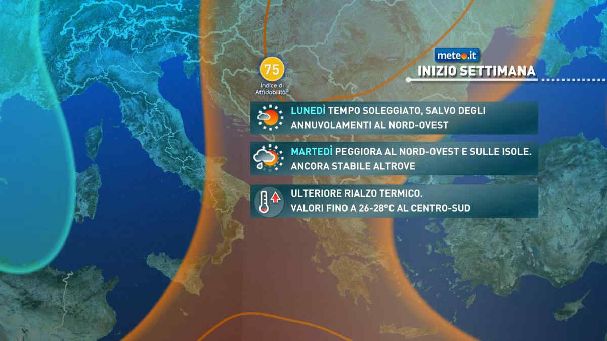
Al mattino cielo molto nuvoloso o coperto con brevi e deboli precipitazioni isolate possibili su Liguria centrale, alto Piemonte e nordovest della Lombardia; limite della neve almeno oltre i 1500-1600 m. Temperature minime in leggero aumento. Nel pomeriggio ancora molte nuvole associate e deboli precipitazioni intermittenti, piu' probabili su Alpi e zone pedemontane, Appennino e Liguria centrale; neve oltre i 1700-1800 m. Temperature massime per lo piu' in ulteriore lieve aumento. Venti finno a moderati in Liguria con mare mosso, venti deboli altrove.

Notizie
TendenzaMeteo, Primo Maggio con la pioggia? Gli ultimi aggiornamenti
Meteo, Primo Maggio con la pioggia? Gli ultimi aggiornamenti
Aprile termina con tempo stabile e clima mite ma per il Primo Maggio si profilano delle piogge specie al Nord. La tendenza meteo
Mediaset

Ultimo aggiornamento Sabato 27 Aprile ore 05:52

Copyright © 1999-2020 RTI S.p.A. Direzione Business Digital - P.Iva 03976881007 - Tutti i diritti riservati - Per la pubblicità Mediamond S.p.a. RTI spa, Gruppo Mediaset - Sede legale: 00187 Roma Largo del Nazareno 8 - Cap. Soc. € 500.000.007,00 int. vers. - Registro delle Imprese di Roma, C.F.06921720154