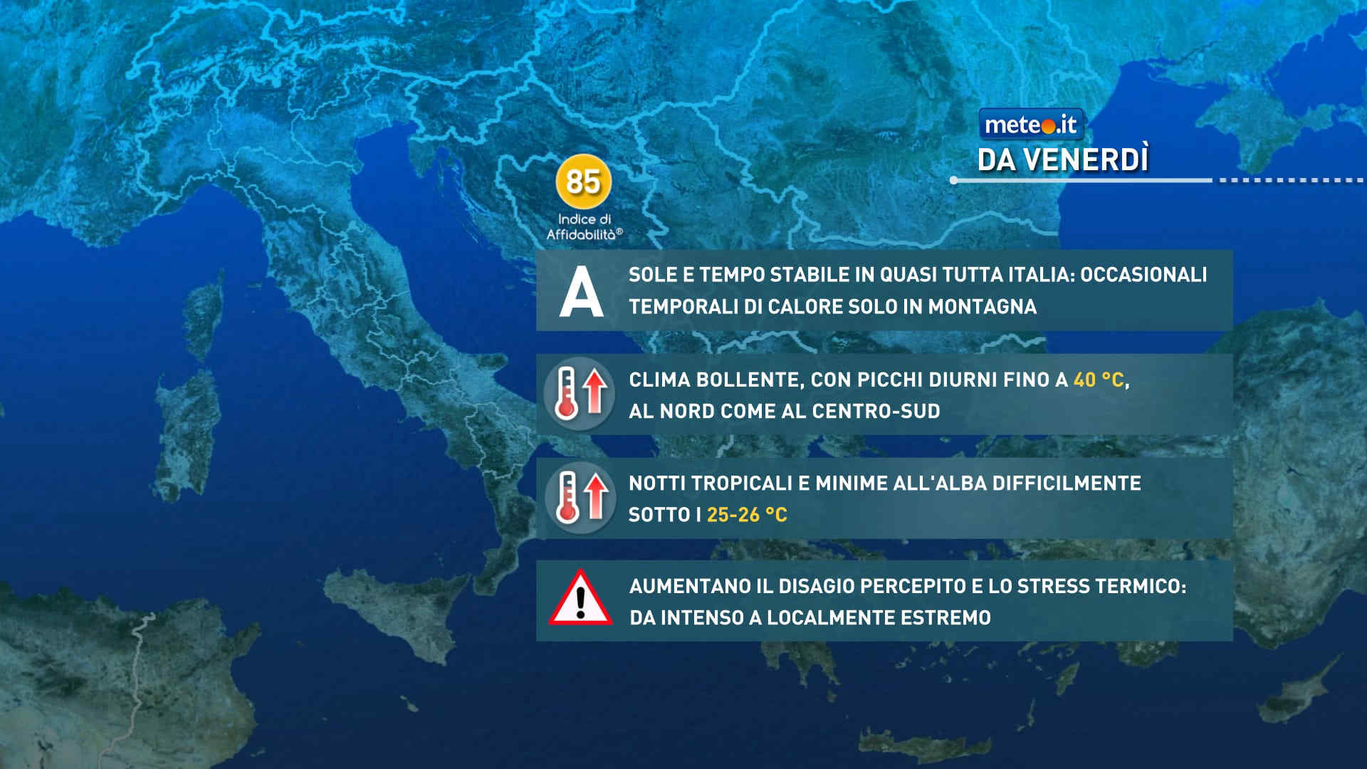
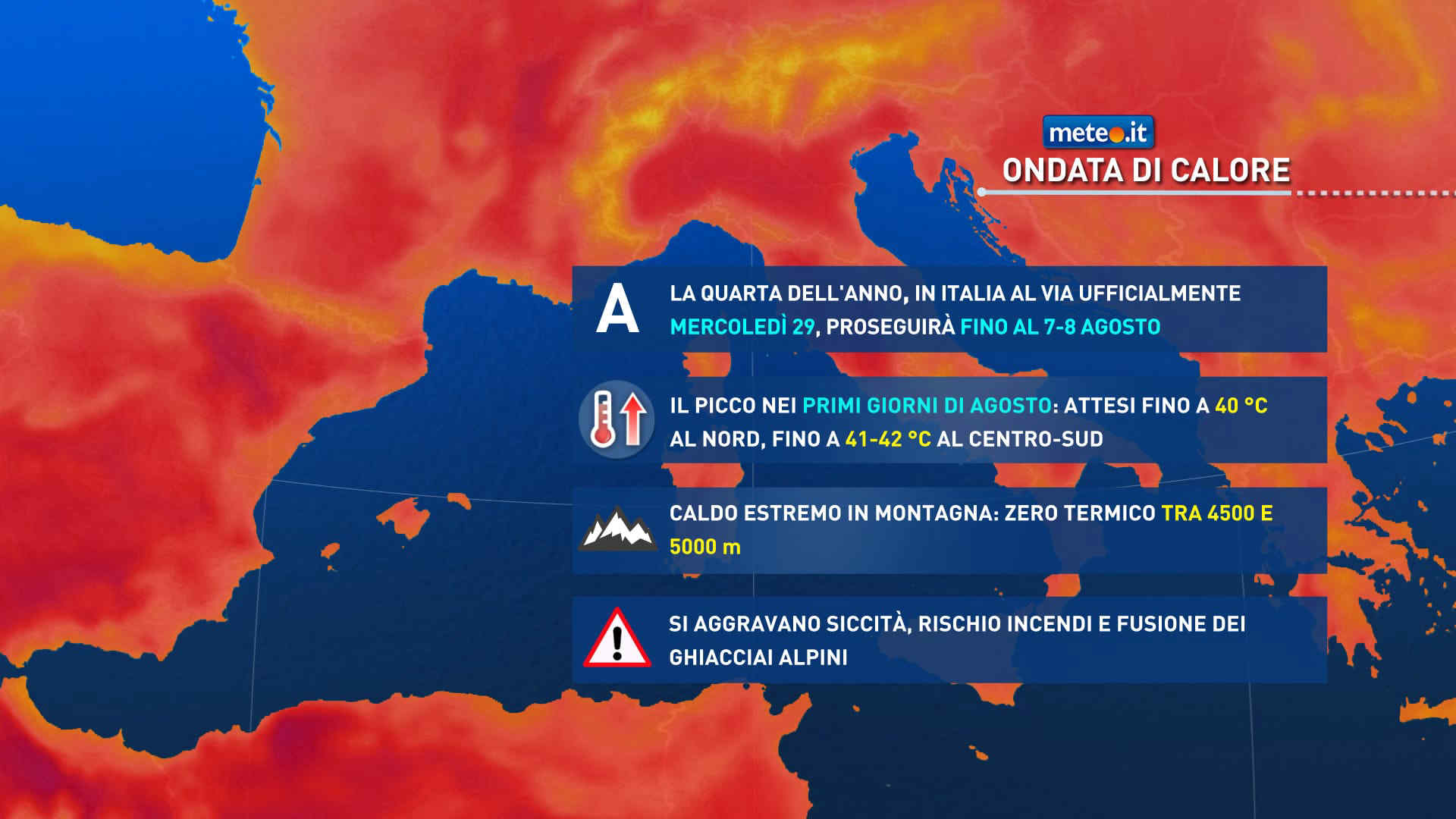
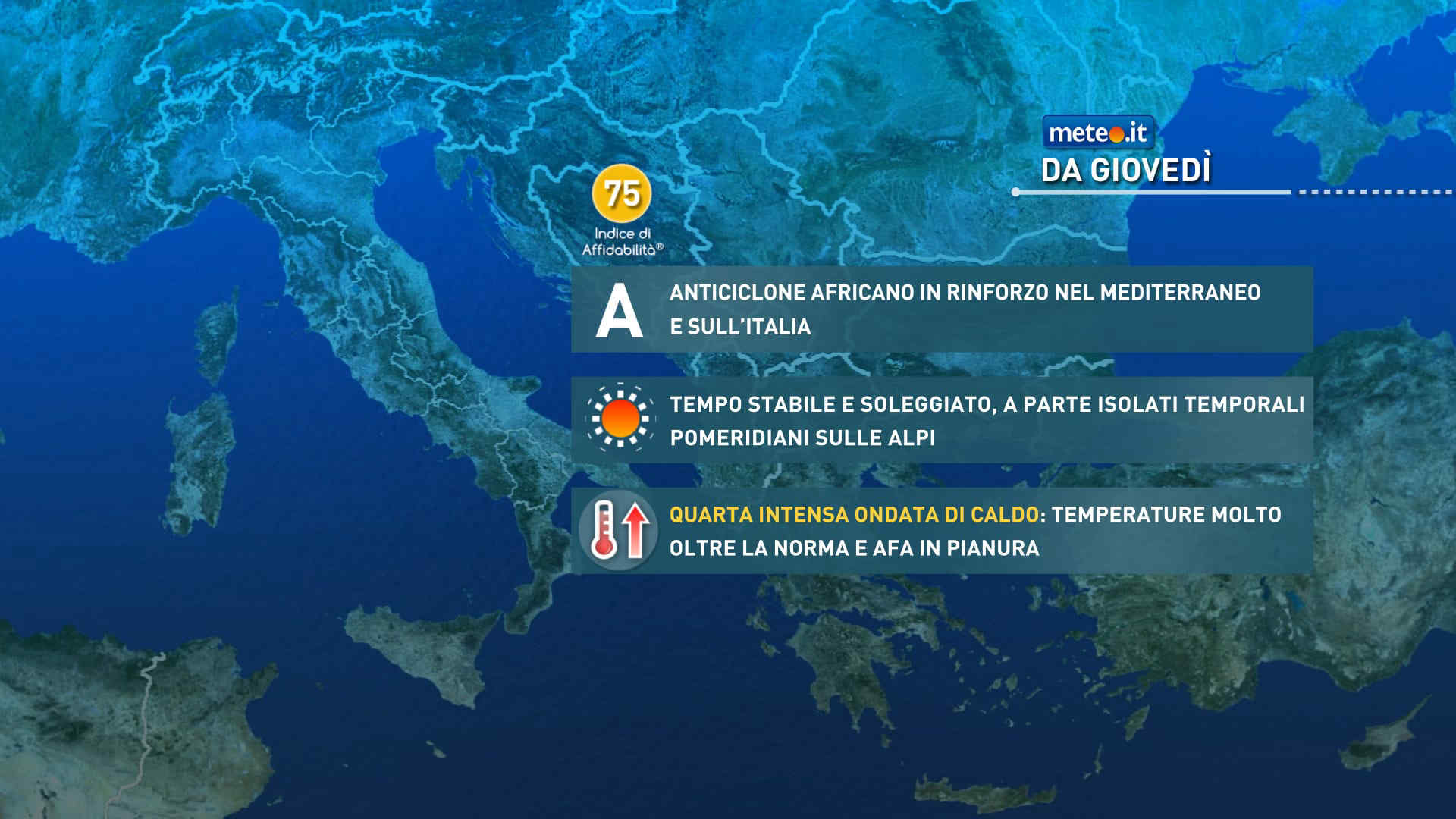
FacebookInstagramTwitterWhatsApp

Meteo Roccalbegna tra 7 giorni. Previsioni del tempo, precipitazioni, temperatura e venti

FacebookWhatsappTwitterTelegram

Roccalbegna
Vento alla sera
06:09
20:13
Gibbosa calante
Notte
sereno notte
Mattino
soleggiato
Pomeriggio
prevalentemente soleggiato
Sera
sereno notte
  • 13°

    UV Normale 0

    ore

    sereno notte

    Umidità normale60%

    Raffiche forti8-19 Km/h

    Sud est intensoSud E

  • 12°

    UV Normale 0

    ore

    sereno notte

    Umidità normale61%

    Raffiche forti8-19 Km/h

    Est sud est intensoEst SE

  • 12°

    UV Normale 0

    ore

    sereno notte

    Umidità normale63%

    Raffiche normali8-18 Km/h

    EstEst

  • 11°

    UV Normale 0

    ore

    sereno notte

    Umidità normale64%

    Raffiche normali8-18 Km/h

    Nord estNord E

  • 11°

    UV Normale 0

    ore

    sereno notte

    Umidità normale65%

    Raffiche normali8-18 Km/h

    Nord estNord E

  • 10°

    UV Normale 0

    ore

    sereno notte

    Umidità normale67%

    Raffiche normali7-17 Km/h

    Nord estNord E

  • 10°

    UV Normale 1

    ore

    soleggiato

    Umidità normale68%

    Raffiche normali7-17 Km/h

    Nord estNord E

  • 12°

    UV Normale 2

    ore

    soleggiato

    Umidità normale61%

    Raffiche normali7-16 Km/h

    Nord estNord E

  • 14°

    UV Normale 4

    ore

    soleggiato

    Umidità normale53%

    Raffiche normali6-16 Km/h

    Est nord estEst NE

  • 16°

    UV Normale 5

    ore

    soleggiato

    Umidità normale46%

    Raffiche normali6-16 Km/h

    Est nord estEst NE

  • 17°

    UV Elevato 6

    ore

    soleggiato

    Umidità normale44%

    Raffiche normali7-18 Km/h

    Est nord estEst NE

  • 18°

    UV Elevato 7

    ore

    soleggiato

    Umidità normale43%

    Raffiche forti8-20 Km/h

    Est nord est intensoEst NE

  • 19°

    UV Elevato 9

    ore

    soleggiato

    Umidità normale41%

    Raffiche forti9-22 Km/h

    Est intensoEst

  • 20°

    UV Elevato 10

    ore

    soleggiato

    Umidità normale39%

    Raffiche forti10-24 Km/h

    Est intensoEst

  • 21°

    UV Elevato 9

    ore

    prevalentemente soleggiato

    Umidità normale37%

    Raffiche forti12-26 Km/h

    Est sud est intensoEst SE

  • 22°

    UV Elevato 7

    ore

    prevalentemente soleggiato

    Umidità normale36%

    Raffiche forti13-28 Km/h

    Sud est intensoSud E

  • 23°

    UV Elevato 6

    ore

    prevalentemente soleggiato

    Umidità normale34%

    Raffiche forti14-29 Km/h

    Est sud est intensoEst SE

  • 22°

    UV Normale 5

    ore

    prevalentemente soleggiato

    Umidità normale38%

    Raffiche forti15-30 Km/h

    Est intensoEst

  • 21°

    UV Normale 4

    ore

    prevalentemente soleggiato

    Umidità normale42%

    Raffiche forti17-31 Km/h

    Nord est intensoNord E

  • 20°

    UV Normale 2

    ore

    prevalentemente soleggiato

    Umidità normale45%

    Raffiche forti18-32 Km/h

    Nord est intensoNord E

  • 19°

    UV Normale 1

    ore

    soleggiato

    Umidità normale49%

    Raffiche forti19-33 Km/h

    Nord nord est intensoNord NE

  • 18°

    UV Normale 0

    ore

    sereno notte

    Umidità normale53%

    Raffiche forti20-35 Km/h

    Nord nord ovest intensoNord NO

  • 18°

    UV Normale 0

    ore

    sereno notte

    Umidità normale53%

    Raffiche forti22-35 Km/h

    Nord intensoNord

  • 18°

    UV Normale 0

    ore

    sereno notte

    Umidità normale52%

    Raffiche forti24-36 Km/h

    Nord intensoNord

  • 17°

    UV Normale 0

    ore

    sereno notte

    Umidità normale52%

    Raffiche forti25-37 Km/h

    Nord nord est intensoNord NE

Meteo provincia di Grosseto
Meteo Centro Italia
Oggi

Al mattino cielo in generale nuvoloso con qualche apertura piu' ampia in Molise. Precipitazioni intermittenti possibili soprattutto in Toscana, Umbria, Marche e alto Lazio; quota neve intorno ai 1000-1200 metri sull'Appennino, anche piu' bassa nel nord della Toscana. Temperature minime stazionarie o in leggero calo. Nel pomeriggio aumento dell'instabilita' con possibile sviluppo di rovesci o temporali a carattere intermittente, meno probabili lungo le coste tirreniche. Neve oltre 800-1400 metri di quota. Alla sera parziale attenuazione dei fenomeni. Temperature massime in calo; valori inferiori alla norma. Un po' ventilato. Mari: poco mossi l'Adriatico e il Ligure orientale, mosso o molto mosso il Tirreno.

Notizie
TendenzaMeteo: ponte del 25 aprile molto variabile. Quando andrà via il freddo artico?
Meteo: ponte del 25 aprile molto variabile. Quando andrà via il freddo artico?
Colpo di coda invernale sull'Italia dove nella seconda parte di settimana si potrebbe vedere un graduale cambiamento. Ponte del 25 aprile incerto
Mediaset

Ultimo aggiornamento Martedì 23 Aprile ore 10:54

Copyright © 1999-2020 RTI S.p.A. Direzione Business Digital - P.Iva 03976881007 - Tutti i diritti riservati - Per la pubblicità Mediamond S.p.a. RTI spa, Gruppo Mediaset - Sede legale: 00187 Roma Largo del Nazareno 8 - Cap. Soc. € 500.000.007,00 int. vers. - Registro delle Imprese di Roma, C.F.06921720154