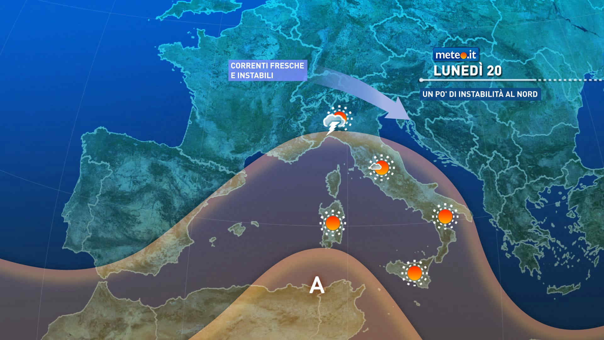
FacebookInstagramTwitterWhatsApp

Meteo Santa Domenica Talao tra 6 giorni. Previsioni del tempo, precipitazioni, temperatura e venti

FacebookWhatsappTwitterTelegram

Santa Domenica Talao
05:58
19:50
Gibbosa calante
Notte
sereno notte
Mattino
soleggiato
Pomeriggio
soleggiato
Sera
sereno notte
  • 15°

    UV Normale 0

    ore

    sereno notte

    Umidità normale57%

    Raffiche normali5-14 Km/h

    EstEst

  • 15°

    UV Normale 0

    ore

    sereno notte

    Umidità normale57%

    Raffiche normali5-15 Km/h

    EstEst

  • 14°

    UV Normale 0

    ore

    sereno notte

    Umidità normale57%

    Raffiche normali5-17 Km/h

    EstEst

  • 14°

    UV Normale 0

    ore

    sereno notte

    Umidità normale57%

    Raffiche normali5-18 Km/h

    Est sud estEst SE

  • 13°

    UV Normale 0

    ore

    sereno notte

    Umidità normale57%

    Raffiche forti7-20 Km/h

    Est sud est intensoEst SE

  • 13°

    UV Normale 1

    ore

    soleggiato

    Umidità normale57%

    Raffiche forti8-22 Km/h

    Est sud est intensoEst SE

  • 15°

    UV Normale 2

    ore

    soleggiato

    Umidità normale54%

    Raffiche forti9-24 Km/h

    Est sud est intensoEst SE

  • 16°

    UV Normale 3

    ore

    soleggiato

    Umidità normale51%

    Raffiche forti11-26 Km/h

    Est intensoEst

  • 18°

    UV Normale 4

    ore

    soleggiato

    Umidità normale47%

    Raffiche forti12-28 Km/h

    Est intensoEst

  • 19°

    UV Elevato 6

    ore

    soleggiato

    Umidità normale44%

    Raffiche forti13-30 Km/h

    Est intensoEst

  • 20°

    UV Elevato 7

    ore

    soleggiato

    Umidità normale43%

    Raffiche forti13-28 Km/h

    Est nord est intensoEst NE

  • 20°

    UV Elevato 8

    ore

    soleggiato

    Umidità normale41%

    Raffiche forti13-25 Km/h

    Nord est intensoNord E

  • 21°

    UV Elevato 9

    ore

    soleggiato

    Umidità normale40%

    Raffiche forti13-23 Km/h

    Nord intensoNord

  • 21°

    UV Elevato 10

    ore

    soleggiato

    Umidità normale39%

    Raffiche forti12-20 Km/h

    Nord nord ovest intensoNord NO

  • 22°

    UV Elevato 9

    ore

    soleggiato

    Umidità normale37%

    Raffiche normali12-18 Km/h

    Nord ovestNord O

  • 22°

    UV Elevato 7

    ore

    soleggiato

    Umidità normale36%

    Raffiche normali12-15 Km/h

    OvestOvest

  • 22°

    UV Elevato 6

    ore

    soleggiato

    Umidità normale37%

    Raffiche forti13-19 Km/h

    Ovest nord ovest intensoOvest NO

  • 21°

    UV Normale 4

    ore

    soleggiato

    Umidità normale39%

    Raffiche forti14-23 Km/h

    Nord ovest intensoNord O

  • 21°

    UV Normale 3

    ore

    soleggiato

    Umidità normale40%

    Raffiche forti15-26 Km/h

    Nord intensoNord

  • 20°

    UV Normale 1

    ore

    soleggiato

    Umidità normale41%

    Raffiche forti16-30 Km/h

    Nord nord est intensoNord NE

  • 20°

    UV Normale 0

    ore

    sereno notte

    Umidità normale43%

    Raffiche forti17-34 Km/h

    Nord est intensoNord E

  • 19°

    UV Normale 0

    ore

    sereno notte

    Umidità normale44%

    Raffiche forti17-38 Km/h

    Est intensoEst

  • 19°

    UV Normale 0

    ore

    sereno notte

    Umidità normale45%

    Raffiche forti19-38 Km/h

    Est intensoEst

  • 19°

    UV Normale 0

    ore

    sereno notte

    Umidità normale45%

    Raffiche forti21-38 Km/h

    Est intensoEst

  • 19°

    UV Normale 0

    ore

    sereno notte

    Umidità normale46%

    Raffiche forti22-38 Km/h

    Est intensoEst

Meteo provincia di Cosenza
Meteo Sud Italia
Oggi

Al mattino nuvolosita' irregolare, piu' consistente nel settore tirrenico dove sara' associata a locali precipitazioni con possibili rovesci o temporali in Campania e neve fino ai 1200-1300 metri sull'Appennino campano e lucano. Temperature minime in calo. Nel pomeriggio ancora prevalenza di nuvole e locali precipitazioni su Campania, Potentino e Calabria. In serata possibili rovesci sulla Calabria tirrenica. Temperature massime in calo e comprese tra 11 e punte di 17-19 gradi. Venti moderati o tesi occidentali. Fino a mosso l'Adriatico, da mossi a molto mossi gli altri mari.

Notizie
TendenzaMeteo, 25 aprile freddo e a rischio pioggia: inverno protagonista per tutto il ponte? La tendenza
Meteo, 25 aprile freddo e a rischio pioggia: inverno protagonista per tutto il ponte? La tendenza
Si confermano condizioni meteo variabili e aria fredda anche giovedì 25 aprile 2024, festa della Liberazione: come prosegue il ponte? La tendenza
Mediaset

Ultimo aggiornamento Mercoledì 24 Aprile ore 02:27

Copyright © 1999-2020 RTI S.p.A. Direzione Business Digital - P.Iva 03976881007 - Tutti i diritti riservati - Per la pubblicità Mediamond S.p.a. RTI spa, Gruppo Mediaset - Sede legale: 00187 Roma Largo del Nazareno 8 - Cap. Soc. € 500.000.007,00 int. vers. - Registro delle Imprese di Roma, C.F.06921720154