FacebookInstagramXWhatsApp

Meteo Châtillon tra 7 giorni. Previsioni del tempo, precipitazioni, temperatura e venti

FacebookWhatsappXTelegram

Châtillon
06:02
16:23
Gibbosa calante
Notte
sereno notte
Mattino
soleggiato
Pomeriggio
soleggiato
Sera
sereno notte
  • 23°

    UV Normale 0

    ore

    sereno notte

    Umidità normale52%

    Raffiche normali6-18 Km/h

    Est nord estEst NE

  • 24°

    UV Normale 0

    ore

    sereno notte

    Umidità normale51%

    Raffiche normali6-14 Km/h

    EstEst

  • 24°

    UV Normale 0

    ore

    sereno notte

    Umidità normale50%

    Raffiche normali5-11 Km/h

    EstEst

  • 25°

    UV Normale 0

    ore

    sereno notte

    Umidità normale48%

    Raffiche normali5-8 Km/h

    Sud estSud E

  • 25°

    UV Normale 0

    ore

    sereno notte

    Umidità normale47%

    Raffiche normali5-8 Km/h

    Sud estSud E

  • 25°

    UV Normale 0

    ore

    sereno notte

    Umidità normale47%

    Raffiche normali5-8 Km/h

    Sud estSud E

  • 25°

    UV Normale 0

    ore

    sereno notte

    Umidità normale46%

    Raffiche normali5-9 Km/h

    Sud estSud E

  • 25°

    UV Normale 1

    ore

    soleggiato

    Umidità normale46%

    Raffiche normali5-9 Km/h

    Sud estSud E

  • 25°

    UV Normale 2

    ore

    soleggiato

    Umidità normale45%

    Raffiche normali5-10 Km/h

    Sud estSud E

  • 25°

    UV Normale 2

    ore

    soleggiato

    Umidità normale45%

    Raffiche normali6-10 Km/h

    Sud estSud E

  • 25°

    UV Normale 3

    ore

    soleggiato

    Umidità normale48%

    Raffiche normali7-11 Km/h

    Sud estSud E

  • 26°

    UV Normale 4

    ore

    soleggiato

    Umidità normale51%

    Raffiche normali8-13 Km/h

    Sud estSud E

  • 26°

    UV Normale 4

    ore

    soleggiato

    Umidità normale55%

    Raffiche normali9-14 Km/h

    Sud estSud E

  • 27°

    UV Normale 5

    ore

    soleggiato

    Umidità normale58%

    Raffiche normali10-15 Km/h

    Sud estSud E

  • 27°

    UV Normale 4

    ore

    soleggiato

    Umidità normale61%

    Raffiche normali11-16 Km/h

    Sud estSud E

  • 27°

    UV Normale 3

    ore

    soleggiato

    Umidità normale62%

    Raffiche normali13-18 Km/h

    Sud estSud E

  • 26°

    UV Normale 2

    ore

    soleggiato

    Umidità normale62%

    Raffiche normali11-16 Km/h

    Sud estSud E

  • 26°

    UV Normale 1

    ore

    soleggiato

    Umidità normale63%

    Raffiche normali10-14 Km/h

    Sud estSud E

  • 26°

    UV Normale 0

    ore

    sereno notte

    Umidità normale64%

    Raffiche normali8-13 Km/h

    Sud estSud E

  • 26°

    UV Normale 0

    ore

    sereno notte

    Umidità normale65%

    Raffiche normali7-11 Km/h

    Est sud estEst SE

  • 25°

    UV Normale 0

    ore

    sereno notte

    Umidità normale65%

    Raffiche normali5-10 Km/h

    Est sud estEst SE

  • 25°

    UV Normale 0

    ore

    sereno notte

    Umidità normale66%

    Raffiche normali4-8 Km/h

    Est sud estEst SE

  • 24°

    UV Normale 0

    ore

    sereno notte

    Umidità normale64%

    Raffiche normali4-8 Km/h

    Est sud estEst SE

  • 22°

    UV Normale 0

    ore

    sereno notte

    Umidità normale63%

    Raffiche normali4-7 Km/h

    Est sud estEst SE

  • 25°

    UV Normale 0

    ore

    sereno notte

    Umidità normale60%

    Raffiche normali4-7 Km/h

    Sud estSud E

Meteo provincia di Aosta
Meteo Nord-Ovest Italia
Oggi

Al mattino piogge e temporali sulla Liguria centrale. Molto nuvoloso anche sulle altre regioni ma con piogge deboli, isolate e intermittenti. Temperature minime senza grandi variazioni. Nel pomeriggio piogge intense e temporalesche sulla Liguria e a ridosso delle aree appenniniche. Piogge moderate in Piemonte e Valle d'Aosta; prime piogge sulla Lombardia a partire dai settori occidentali. In serata diffuso e intenso maltempo in tutte le regioni con locali forti precipitazioni. Temperature massime in calo. Venti forti di Scirocco in Liguria e a ridosso dell'Appennino; generalmente deboli o al piu' moderati altrove. Mare da mosso a molto mosso.


Ultime newsVedi tutte


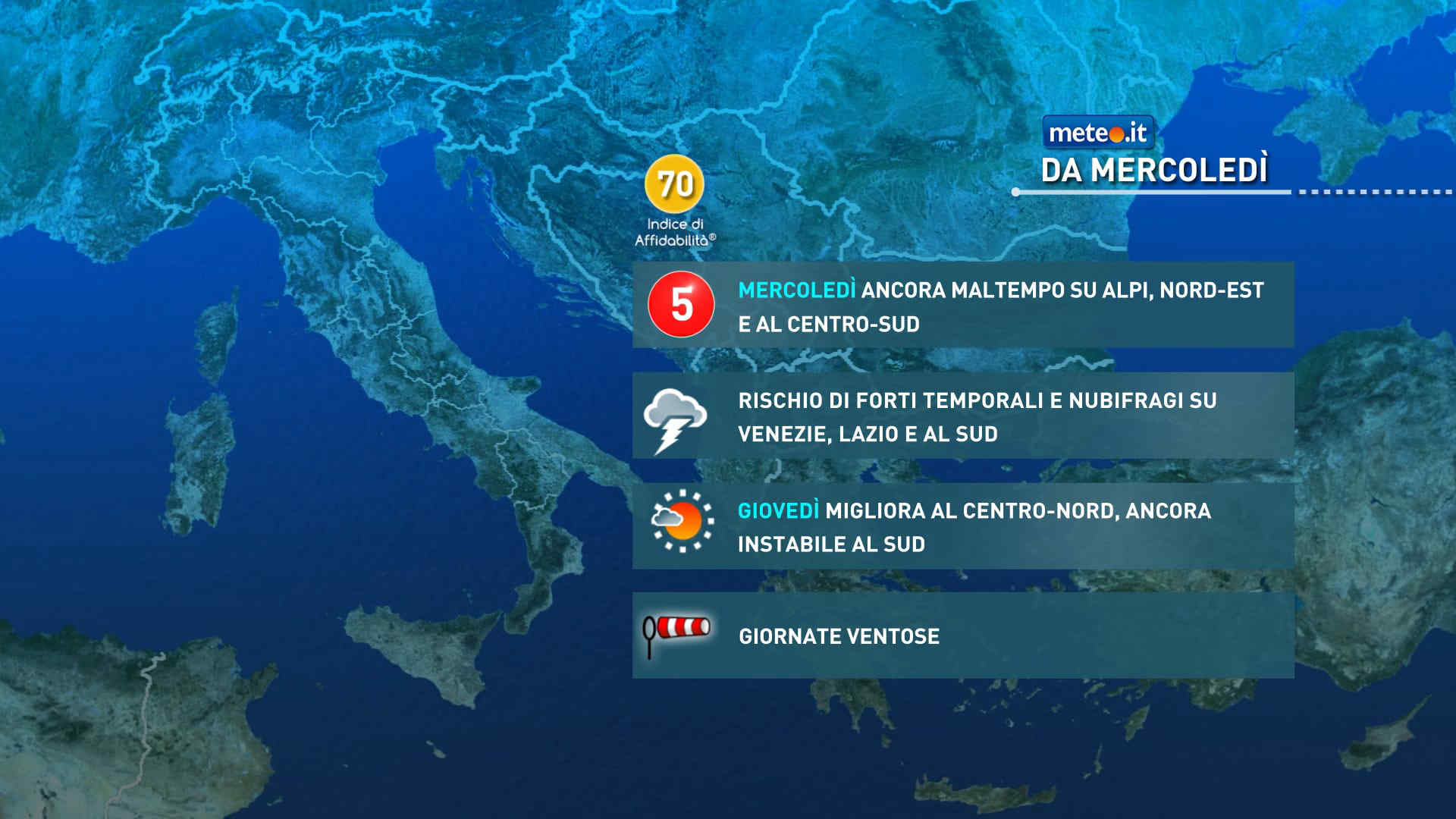
Giovedì tregua dal maltempo, ma ci sono nuove perturbazioni in arrivo verso il weekend. La tendenza dal 22 ottobre
Tendenza19 Ottobre 2026
Giovedì tregua dal maltempo, ma ci sono nuove perturbazioni in arrivo verso il weekend. La tendenza dal 22 ottobre
Il forte maltempo che colpirà l'Italia tra martedì e mercoledì si attenuerà nella giornata di giovedì, ma la scena meteo resta dinamica
Meteo: 21 ottobre piogge intense e abbondanti! Occhio ai venti
Tendenza18 Ottobre 2026
Meteo: 21 ottobre piogge intense e abbondanti! Occhio ai venti
La tendenza meteo da mercoledì 21 ottobre vede ancora un forte maltempo con possibili nubifragi e piogge abbondanti. Attenzione anche ai venti.
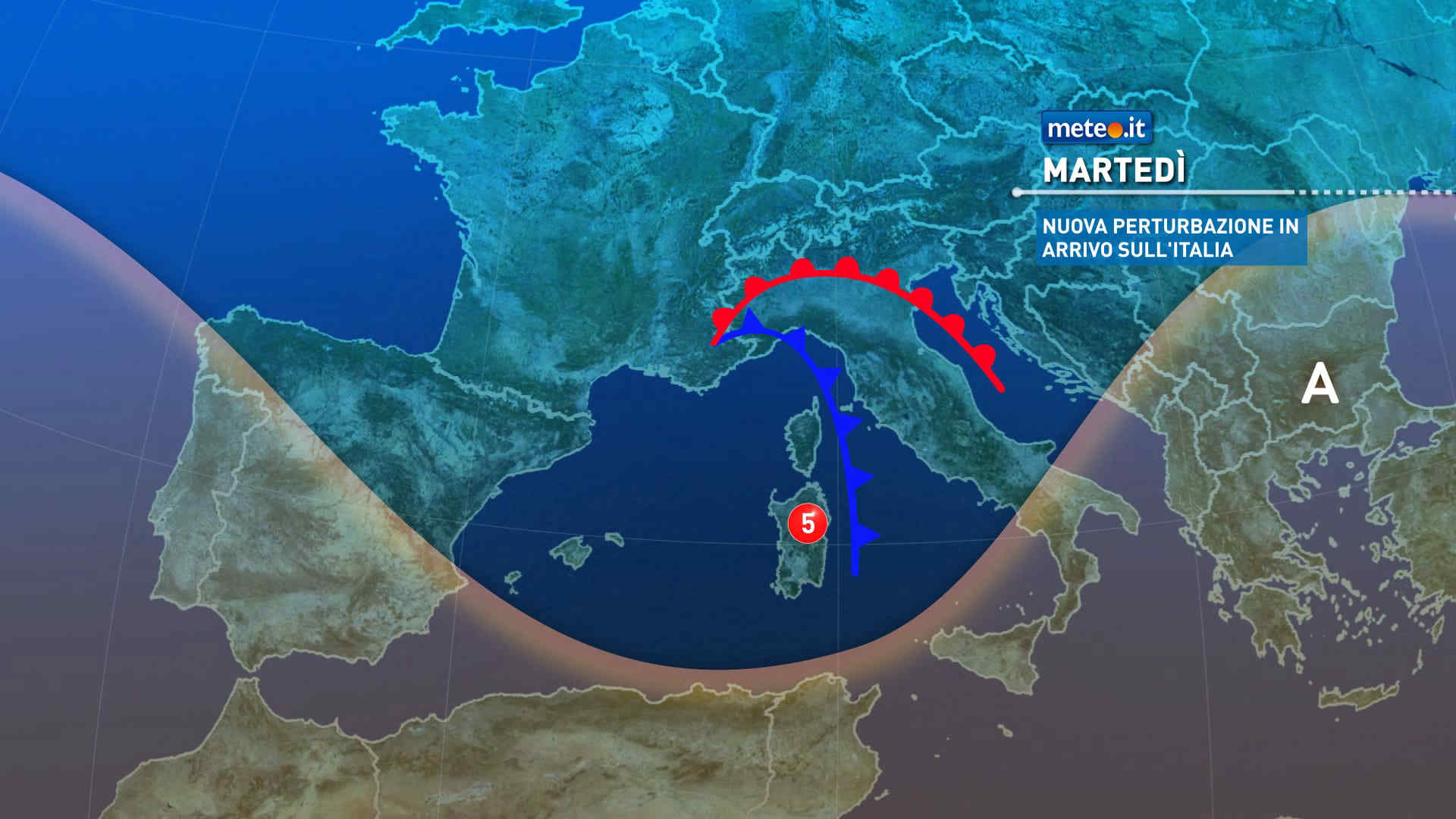
Meteo, forte maltempo in arrivo da martedì 20 ottobre: le zone più a rischio
Tendenza17 Ottobre 2026
Meteo, forte maltempo in arrivo da martedì 20 ottobre: le zone più a rischio
Una perturbazione investirà l'Italia martedì, dando il via a una fase di maltempo intenso: vento forte, piogge abbondanti e rischio allagamenti
Mediaset

Ultimo aggiornamento Martedì 20 Ottobre ore 00:13

Copyright © 1999-2020 RTI S.p.A. Direzione Business Digital - P.Iva 03976881007 - Tutti i diritti riservati.

Rispetto ai contenuti e ai dati personali trasmessi e/o riprodotti è vietata ogni utilizzazione funzionale all'addestramento di sistemi di intelligenza artificiale generativa. È altresì fatto divieto espresso di utilizzare mezzi automatizzati di data scraping.

Per la pubblicità Mediamond S.p.a. RTI spa, Gruppo Mediaset - Sede legale: 00187 Roma Largo del Nazareno 8 - Cap. Soc. € 500.000.007,00 int. vers. - Registro delle Imprese di Roma, C.F.06921720154