FacebookInstagramTwitterWhatsApp

Meteo Nureci tra 9 giorni. Previsioni del tempo, precipitazioni, temperatura e venti

FacebookWhatsappTwitterTelegram

Nureci
Notte
sereno notte
Mattino
soleggiato
Pomeriggio
soleggiato
Sera
poco nuvoloso
  • 13°

    UV Normale 0

    ore

    sereno notte

    Umidità alta72%

    Raffiche forti11-23 Km/h

    Nord intensoNord

  • 12°

    UV Normale 0

    ore

    sereno notte

    Umidità alta73%

    Raffiche forti9-20 Km/h

    Nord intensoNord

  • 12°

    UV Normale 0

    ore

    sereno notte

    Umidità alta74%

    Raffiche normali7-16 Km/h

    Nord nord estNord NE

  • 11°

    UV Normale 0

    ore

    sereno notte

    Umidità alta75%

    Raffiche normali5-12 Km/h

    Nord estNord E

  • 10°

    UV Normale 0

    ore

    sereno notte

    Umidità alta75%

    Raffiche normali6-13 Km/h

    Nord estNord E

  • 10°

    UV Normale 0

    ore

    sereno notte

    Umidità alta76%

    Raffiche normali6-14 Km/h

    Est nord estEst NE

  • UV Normale 1

    ore

    soleggiato

    Umidità alta77%

    Raffiche normali7-14 Km/h

    Est nord estEst NE

  • 11°

    UV Normale 2

    ore

    soleggiato

    Umidità normale70%

    Raffiche normali7-15 Km/h

    EstEst

  • 14°

    UV Normale 4

    ore

    soleggiato

    Umidità normale64%

    Raffiche normali7-15 Km/h

    EstEst

  • 16°

    UV Normale 5

    ore

    soleggiato

    Umidità normale57%

    Raffiche normali8-16 Km/h

    Est sud estEst SE

  • 17°

    UV Elevato 7

    ore

    soleggiato

    Umidità normale52%

    Raffiche normali9-17 Km/h

    Sud estSud E

  • 19°

    UV Elevato 8

    ore

    soleggiato

    Umidità normale48%

    Raffiche normali10-17 Km/h

    Sud sud estSud SE

  • 20°

    UV Elevato 10

    ore

    soleggiato

    Umidità normale43%

    Raffiche normali11-18 Km/h

    SudSud

  • 21°

    UV Elevato 11

    ore

    soleggiato

    Umidità normale39%

    Raffiche forti13-19 Km/h

    Sud sud ovest intensoSud SO

  • 22°

    UV Elevato 10

    ore

    soleggiato

    Umidità normale34%

    Raffiche forti14-20 Km/h

    Sud ovest intensoSud O

  • 24°

    UV Elevato 8

    ore

    soleggiato

    Umidità normale30%

    Raffiche forti15-21 Km/h

    Ovest intensoOvest

  • 25°

    UV Elevato 7

    ore

    soleggiato

    Umidità normale25%

    Raffiche forti14-21 Km/h

    Ovest intensoOvest

  • 24°

    UV Normale 5

    ore

    soleggiato

    Umidità normale31%

    Raffiche forti13-21 Km/h

    Ovest intensoOvest

  • 22°

    UV Normale 4

    ore

    soleggiato

    Umidità normale36%

    Raffiche forti12-21 Km/h

    Ovest intensoOvest

  • 21°

    UV Normale 2

    ore

    soleggiato

    Umidità normale42%

    Raffiche forti11-22 Km/h

    Ovest intensoOvest

  • 19°

    UV Normale 1

    ore

    prevalentemente soleggiato

    Umidità normale47%

    Raffiche forti11-22 Km/h

    Ovest intensoOvest

  • 18°

    UV Normale 0

    ore

    poco nuvoloso

    Umidità normale53%

    Raffiche forti10-22 Km/h

    Ovest intensoOvest

  • 18°

    UV Normale 0

    ore

    poco nuvoloso

    Umidità normale54%

    Raffiche forti9-21 Km/h

    Ovest sud ovest intensoOvest SO

  • 17°

    UV Normale 0

    ore

    poco nuvoloso

    Umidità normale55%

    Raffiche forti9-21 Km/h

    Sud ovest intensoSud O

  • 16°

    UV Normale 0

    ore

    poco nuvoloso

    Umidità normale56%

    Raffiche forti9-20 Km/h

    Sud intensoSud

Meteo provincia di Oristano
Meteo Sardegna Italia
Oggi

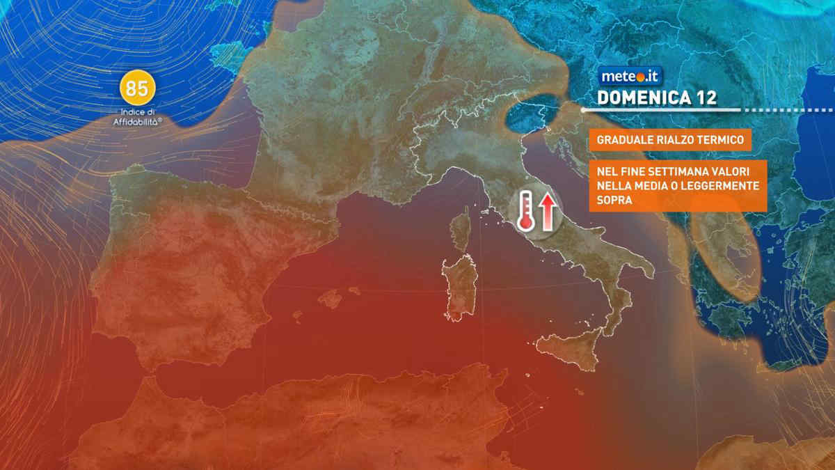
Al mattino cielo in prevalenza poco nuvoloso, salvo locali addensamenti nel sudovest della regione. Temperature minime in leggero rialzo. Nel pomeriggio tempo prevalentemente soleggiato. Nelle ore piu' calde formazioni di cumuli nelle zone interne e nel sud dell'isola, dove non si escludono brevi rovesci e temporali. Temperature massime stazionarie o in lieve aumento. Venti: generalmente deboli sull'isola; moderati settentrionali sul mar Tirreno. Mari: poco mossi, localmente mosso il Tirreno.

Notizie
TendenzaMeteo, prossima settimana tra piogge e caldo anomalo: la tendenza dal 13 maggio
Meteo, prossima settimana tra piogge e caldo anomalo: la tendenza dal 13 maggio
Per la prossima settimana si profila un'Italia divisa in due: torna la pioggia al Nord, caldo anomalo al Centro-Sud. La tendenza meteo
Mediaset

Ultimo aggiornamento Venerdì 10 Maggio ore 22:20

Copyright © 1999-2020 RTI S.p.A. Direzione Business Digital - P.Iva 03976881007 - Tutti i diritti riservati - Per la pubblicità Mediamond S.p.a. RTI spa, Gruppo Mediaset - Sede legale: 00187 Roma Largo del Nazareno 8 - Cap. Soc. € 500.000.007,00 int. vers. - Registro delle Imprese di Roma, C.F.06921720154