FacebookInstagramTwitterWhatsApp

Meteo Monte Amiata tra 9 giorni. Previsioni del tempo, precipitazioni, temperatura e venti

FacebookWhatsappTwitterTelegram

Monte Amiata
Notte
sereno notte
Mattino
soleggiato
Pomeriggio
soleggiato
Sera
sereno notte
  • 11°

    UV Normale 0

    ore

    sereno notte

    Umidità normale52%

    Raffiche normali9-18 Km/h

    OvestOvest

  • 11°

    UV Normale 0

    ore

    sereno notte

    Umidità normale52%

    Raffiche normali7-16 Km/h

    OvestOvest

  • 11°

    UV Normale 0

    ore

    sereno notte

    Umidità normale52%

    Raffiche normali6-14 Km/h

    OvestOvest

  • 11°

    UV Normale 0

    ore

    sereno notte

    Umidità normale53%

    Raffiche normali5-11 Km/h

    OvestOvest

  • 10°

    UV Normale 0

    ore

    sereno notte

    Umidità normale53%

    Raffiche normali4-11 Km/h

    OvestOvest

  • 10°

    UV Normale 1

    ore

    soleggiato

    Umidità normale53%

    Raffiche normali4-11 Km/h

    Ovest nord ovestOvest NO

  • 11°

    UV Normale 2

    ore

    soleggiato

    Umidità normale50%

    Raffiche normali4-11 Km/h

    Ovest nord ovestOvest NO

  • 11°

    UV Normale 3

    ore

    soleggiato

    Umidità normale47%

    Raffiche normali4-11 Km/h

    Ovest nord ovestOvest NO

  • 12°

    UV Normale 4

    ore

    soleggiato

    Umidità normale44%

    Raffiche normali4-11 Km/h

    Ovest nord ovestOvest NO

  • 12°

    UV Elevato 6

    ore

    soleggiato

    Umidità normale41%

    Raffiche normali3-10 Km/h

    Ovest nord ovestOvest NO

  • 13°

    UV Elevato 7

    ore

    soleggiato

    Umidità normale40%

    Raffiche normali5-12 Km/h

    Ovest nord ovestOvest NO

  • 13°

    UV Elevato 8

    ore

    soleggiato

    Umidità normale40%

    Raffiche normali7-14 Km/h

    Ovest nord ovestOvest NO

  • 14°

    UV Elevato 9

    ore

    soleggiato

    Umidità normale39%

    Raffiche normali9-16 Km/h

    Ovest nord ovestOvest NO

  • 15°

    UV Elevato 10

    ore

    soleggiato

    Umidità normale38%

    Raffiche normali11-18 Km/h

    Ovest nord ovestOvest NO

  • 16°

    UV Elevato 9

    ore

    soleggiato

    Umidità normale37%

    Raffiche forti13-20 Km/h

    Ovest nord ovest intensoOvest NO

  • 16°

    UV Elevato 7

    ore

    soleggiato

    Umidità normale37%

    Raffiche forti14-22 Km/h

    Ovest nord ovest intensoOvest NO

  • 17°

    UV Elevato 6

    ore

    soleggiato

    Umidità normale36%

    Raffiche forti14-21 Km/h

    Ovest nord ovest intensoOvest NO

  • 16°

    UV Normale 5

    ore

    soleggiato

    Umidità normale39%

    Raffiche forti13-21 Km/h

    Ovest intensoOvest

  • 16°

    UV Normale 4

    ore

    soleggiato

    Umidità normale42%

    Raffiche forti12-21 Km/h

    Ovest intensoOvest

  • 15°

    UV Normale 2

    ore

    soleggiato

    Umidità normale44%

    Raffiche forti11-20 Km/h

    Ovest sud ovest intensoOvest SO

  • 15°

    UV Normale 1

    ore

    soleggiato

    Umidità normale47%

    Raffiche forti10-20 Km/h

    Ovest sud ovest intensoOvest SO

  • 14°

    UV Normale 0

    ore

    sereno notte

    Umidità normale50%

    Raffiche forti10-20 Km/h

    Sud ovest intensoSud O

  • 14°

    UV Normale 0

    ore

    sereno notte

    Umidità normale50%

    Raffiche forti9-20 Km/h

    Sud ovest intensoSud O

  • 14°

    UV Normale 0

    ore

    sereno notte

    Umidità normale49%

    Raffiche forti9-20 Km/h

    Sud ovest intensoSud O

  • 12°

    UV Normale 0

    ore

    sereno notte

    Umidità normale47%

    Raffiche forti7-20 Km/h

    Sud sud ovest intensoSud SO

Meteo provincia di Siena
Meteo Centro Italia
Oggi

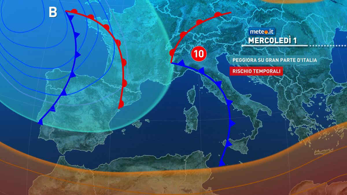
Al mattino lungo la costa adriatica cielo sereno o poco nuvoloso. Per il resto cielo nuvoloso, fino a molto nuvoloso o coperto e con precipitazioni su Toscana, Umbria e Lazio. Possibili rovesci o temporali. Temperature minime senza grosse variazioni. Nel pomeriggio cielo nuvoloso o molto nuvoloso e tempo molto instabile, ovunque con il rischio di precipitazioni sparse, a prevalente carattere di rovescio o temporale. In serata i fenomeni tenderanno a concentrarsi nel settore tirrenico. Temperature massime in diminuzione, non oltre i 20-21 radi del lato adriatico. Venti: da moderati a localmente forti di Libeccio. Mari: molto mosso il Tirreno, mosso al largo l'Adriatico.

Notizie
TendenzaMeteo, weekend del 4-5 maggio più stabile: le previsioni
Meteo, weekend del 4-5 maggio più stabile: le previsioni
Nel primo weekend di maggio situazione in miglioramento con temperature in aumento e punte di 25-26 gradi domenica 5 maggio. La tendenza meteo
Mediaset

Ultimo aggiornamento Giovedì 02 Maggio ore 00:31

Copyright © 1999-2020 RTI S.p.A. Direzione Business Digital - P.Iva 03976881007 - Tutti i diritti riservati - Per la pubblicità Mediamond S.p.a. RTI spa, Gruppo Mediaset - Sede legale: 00187 Roma Largo del Nazareno 8 - Cap. Soc. € 500.000.007,00 int. vers. - Registro delle Imprese di Roma, C.F.06921720154