FacebookInstagramTwitterWhatsApp

Meteo Bagno di Romagna tra 4 giorni. Previsioni del tempo, precipitazioni, temperatura e venti

FacebookWhatsappTwitterTelegram

Bagno di Romagna
06:05
20:14
Gibbosa calante
Notte
sereno notte
Mattino
prevalentemente soleggiato
Pomeriggio
prevalentemente soleggiato
Sera
cielo in gran parte nuvoloso
  • UV Normale 0

    ore

    sereno notte

    Umidità alta72%

    Raffiche normali5-13 Km/h

    Est sud estEst SE

  • UV Normale 0

    ore

    sereno notte

    Umidità alta72%

    Raffiche normali5-12 Km/h

    Est sud estEst SE

  • UV Normale 0

    ore

    sereno notte

    Umidità alta72%

    Raffiche normali5-11 Km/h

    Sud estSud E

  • UV Normale 0

    ore

    sereno notte

    Umidità alta72%

    Raffiche normali4-10 Km/h

    Sud estSud E

  • UV Normale 0

    ore

    sereno notte

    Umidità alta71%

    Raffiche normali5-10 Km/h

    Sud estSud E

  • UV Normale 0

    ore

    sereno notte

    Umidità alta71%

    Raffiche normali5-11 Km/h

    Sud sud estSud SE

  • UV Normale 1

    ore

    soleggiato

    Umidità alta71%

    Raffiche normali5-11 Km/h

    Sud sud estSud SE

  • UV Normale 2

    ore

    soleggiato

    Umidità normale68%

    Raffiche normali5-11 Km/h

    Sud sud estSud SE

  • 12°

    UV Normale 3

    ore

    prevalentemente soleggiato

    Umidità normale64%

    Raffiche normali6-11 Km/h

    Sud sud estSud SE

  • 15°

    UV Normale 4

    ore

    prevalentemente soleggiato

    Umidità normale61%

    Raffiche normali6-11 Km/h

    Sud sud estSud SE

  • 17°

    UV Elevato 6

    ore

    prevalentemente soleggiato

    Umidità normale59%

    Raffiche normali7-12 Km/h

    Sud sud estSud SE

  • 18°

    UV Elevato 7

    ore

    prevalentemente soleggiato

    Umidità normale58%

    Raffiche normali8-13 Km/h

    Sud estSud E

  • 20°

    UV Elevato 8

    ore

    prevalentemente soleggiato

    Umidità normale56%

    Raffiche normali9-13 Km/h

    Est sud estEst SE

  • 21°

    UV Elevato 9

    ore

    prevalentemente soleggiato

    Umidità normale54%

    Raffiche normali9-14 Km/h

    EstEst

  • 23°

    UV Elevato 8

    ore

    prevalentemente soleggiato

    Umidità normale53%

    Raffiche normali10-15 Km/h

    EstEst

  • 24°

    UV Elevato 7

    ore

    prevalentemente soleggiato

    Umidità normale51%

    Raffiche normali11-15 Km/h

    Nord estNord E

  • 22°

    UV Elevato 6

    ore

    prevalentemente soleggiato

    Umidità normale56%

    Raffiche normali11-15 Km/h

    Est nord estEst NE

  • 21°

    UV Normale 4

    ore

    prevalentemente soleggiato

    Umidità normale61%

    Raffiche normali10-15 Km/h

    Est nord estEst NE

  • 19°

    UV Normale 3

    ore

    prevalentemente soleggiato

    Umidità normale66%

    Raffiche normali9-15 Km/h

    Est nord estEst NE

  • 17°

    UV Normale 2

    ore

    prevalentemente soleggiato

    Umidità alta71%

    Raffiche normali9-14 Km/h

    Est nord estEst NE

  • 16°

    UV Normale 1

    ore

    cielo in gran parte nuvoloso

    Umidità alta76%

    Raffiche normali8-14 Km/h

    Est nord estEst NE

  • 14°

    UV Normale 0

    ore

    cielo in gran parte nuvoloso

    Umidità alta81%

    Raffiche normali8-14 Km/h

    EstEst

  • 13°

    UV Normale 0

    ore

    cielo in gran parte nuvoloso

    Umidità alta82%

    Raffiche normali7-14 Km/h

    Est nord estEst NE

  • 13°

    UV Normale 0

    ore

    cielo in gran parte nuvoloso

    Umidità alta83%

    Raffiche normali7-13 Km/h

    Est nord estEst NE

  • 12°

    UV Normale 0

    ore

    cielo in gran parte nuvoloso

    Umidità alta84%

    Raffiche normali7-13 Km/h

    Est nord estEst NE

Meteo provincia di Forli'-Cesena
Meteo Nord-Est Italia
Oggi

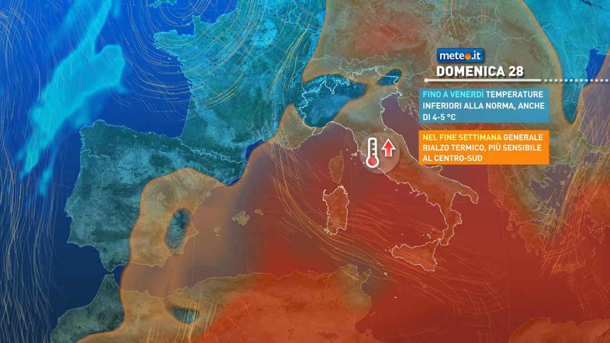
Al mattino cielo in prevalenza nuvoloso, salvo residue schiarite lungo la costa veneta. Temperature minime in leggero rialzo. Nel pomeriggio cielo nuvoloso. Brevi rovesci isolati saranno piu' probabili sull'Emilia Romagna; deboli precipitazioni isolate su Alpi e Prealpi, nevose sopra 1500-1600. Temperature massime in lieve aumento. Venti in prevalenza deboli. Mare adriatico da poco mosso a localmente mosso.

Notizie
TendenzaMeteo, dal 28 aprile picchi oltre 25 gradi: ecco dove
Meteo, dal 28 aprile picchi oltre 25 gradi: ecco dove
Temperature in netto aumento: si torna sopra le medie soprattutto al Centro-sud e sulle Isole dove potremo superare i 25 gradi. La tendenza meteo
Mediaset

Ultimo aggiornamento Venerdì 26 Aprile ore 10:28

Copyright © 1999-2020 RTI S.p.A. Direzione Business Digital - P.Iva 03976881007 - Tutti i diritti riservati - Per la pubblicità Mediamond S.p.a. RTI spa, Gruppo Mediaset - Sede legale: 00187 Roma Largo del Nazareno 8 - Cap. Soc. € 500.000.007,00 int. vers. - Registro delle Imprese di Roma, C.F.06921720154