FacebookInstagramTwitterWhatsApp

Meteo Borgarello tra 8 giorni. Previsioni del tempo, precipitazioni, temperatura e venti

FacebookWhatsappTwitterTelegram

Borgarello
Notte
poco nuvoloso
Mattino
prevalentemente soleggiato
Pomeriggio
soleggiato
Sera
poco nuvoloso
  • 13°

    UV Normale 0

    ore

    sereno notte

    Umidità normale59%

    Raffiche forti14-33 Km/h

    Ovest sud ovest intensoOvest SO

  • 12°

    UV Normale 0

    ore

    sereno notte

    Umidità normale62%

    Raffiche forti13-32 Km/h

    Ovest sud ovest intensoOvest SO

  • 11°

    UV Normale 0

    ore

    poco nuvoloso

    Umidità normale65%

    Raffiche forti12-32 Km/h

    Ovest sud ovest intensoOvest SO

  • 10°

    UV Normale 0

    ore

    poco nuvoloso

    Umidità normale68%

    Raffiche forti12-31 Km/h

    Ovest sud ovest intensoOvest SO

  • 10°

    UV Normale 0

    ore

    poco nuvoloso

    Umidità alta71%

    Raffiche forti11-29 Km/h

    Ovest sud ovest intensoOvest SO

  • UV Normale 0

    ore

    poco nuvoloso

    Umidità alta74%

    Raffiche forti11-26 Km/h

    Ovest sud ovest intensoOvest SO

  • UV Normale 1

    ore

    prevalentemente soleggiato

    Umidità alta77%

    Raffiche forti10-24 Km/h

    Ovest intensoOvest

  • UV Normale 2

    ore

    prevalentemente soleggiato

    Umidità alta79%

    Raffiche forti10-21 Km/h

    Ovest intensoOvest

  • 10°

    UV Normale 4

    ore

    prevalentemente soleggiato

    Umidità alta81%

    Raffiche forti10-19 Km/h

    Ovest intensoOvest

  • 11°

    UV Normale 5

    ore

    prevalentemente soleggiato

    Umidità alta83%

    Raffiche normali9-17 Km/h

    OvestOvest

  • 12°

    UV Elevato 6

    ore

    prevalentemente soleggiato

    Umidità alta77%

    Raffiche normali9-18 Km/h

    OvestOvest

  • 14°

    UV Elevato 7

    ore

    prevalentemente soleggiato

    Umidità alta71%

    Raffiche forti10-20 Km/h

    Ovest sud ovest intensoOvest SO

  • 15°

    UV Elevato 9

    ore

    prevalentemente soleggiato

    Umidità normale65%

    Raffiche forti10-22 Km/h

    Ovest sud ovest intensoOvest SO

  • 17°

    UV Elevato 10

    ore

    prevalentemente soleggiato

    Umidità normale58%

    Raffiche forti11-24 Km/h

    Ovest sud ovest intensoOvest SO

  • 18°

    UV Elevato 9

    ore

    soleggiato

    Umidità normale52%

    Raffiche forti11-26 Km/h

    Sud ovest intensoSud O

  • 20°

    UV Elevato 7

    ore

    soleggiato

    Umidità normale46%

    Raffiche forti11-28 Km/h

    Sud ovest intensoSud O

  • 21°

    UV Elevato 6

    ore

    soleggiato

    Umidità normale40%

    Raffiche forti13-31 Km/h

    Sud ovest intensoSud O

  • 20°

    UV Normale 5

    ore

    soleggiato

    Umidità normale45%

    Raffiche forti14-33 Km/h

    Sud ovest intensoSud O

  • 19°

    UV Normale 4

    ore

    soleggiato

    Umidità normale50%

    Raffiche forti15-36 Km/h

    Sud ovest intensoSud O

  • 17°

    UV Normale 2

    ore

    soleggiato

    Umidità normale56%

    Raffiche forti17-39 Km/h

    Ovest sud ovest intensoOvest SO

  • 16°

    UV Normale 1

    ore

    prevalentemente soleggiato

    Umidità normale61%

    Raffiche forti18-42 Km/h

    Ovest sud ovest intensoOvest SO

  • 15°

    UV Normale 0

    ore

    poco nuvoloso

    Umidità normale66%

    Raffiche forti19-44 Km/h

    Ovest sud ovest intensoOvest SO

  • 15°

    UV Normale 0

    ore

    poco nuvoloso

    Umidità normale70%

    Raffiche forti17-40 Km/h

    Ovest intensoOvest

  • 14°

    UV Normale 0

    ore

    poco nuvoloso

    Umidità alta74%

    Raffiche forti15-35 Km/h

    Ovest intensoOvest

  • 14°

    UV Normale 0

    ore

    poco nuvoloso

    Umidità alta76%

    Raffiche forti13-30 Km/h

    Ovest nord ovest intensoOvest NO

Meteo provincia di Pavia
Meteo Nord-Ovest Italia
Oggi

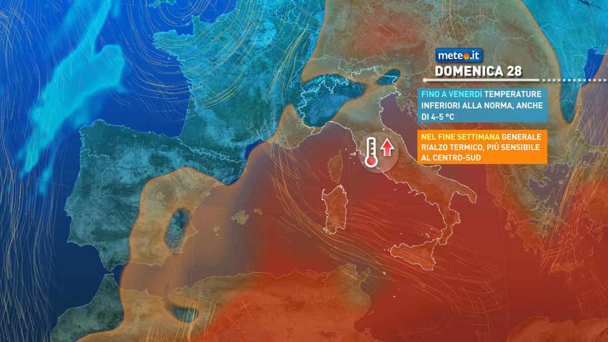
Al mattino cielo nuvoloso o molto nuvoloso. Possibilita' di deboli piogge isolate sulla Liguria centrale e sul Piemonte orientale. Neve sopra 1200 m circa. Temperature minime in leggero rialzo. Nel pomeriggio cielo molto nuvoloso o coperto. Localmente potranno verificarsi deboli precipitazioni, specie nel settore delle Alpi occidentali e dell'Appennino. Neve sopra 1500-1600 m. Temperature massime in contenuto calo sul Piemonte. Venti in prevalenza deboli. Mar Ligure poco mosso.

Notizie
TendenzaMeteo, dal 28 aprile picchi oltre 25 gradi: ecco dove
Meteo, dal 28 aprile picchi oltre 25 gradi: ecco dove
Temperature in netto aumento: si torna sopra le medie soprattutto al Centro-sud e sulle Isole dove potremo superare i 25 gradi. La tendenza meteo
Mediaset

Ultimo aggiornamento Venerdì 26 Aprile ore 00:33

Copyright © 1999-2020 RTI S.p.A. Direzione Business Digital - P.Iva 03976881007 - Tutti i diritti riservati - Per la pubblicità Mediamond S.p.a. RTI spa, Gruppo Mediaset - Sede legale: 00187 Roma Largo del Nazareno 8 - Cap. Soc. € 500.000.007,00 int. vers. - Registro delle Imprese di Roma, C.F.06921720154