FacebookInstagramTwitterWhatsApp

Meteo Bisenti tra 8 giorni. Previsioni del tempo, precipitazioni, temperatura e venti

FacebookWhatsappTwitterTelegram

Bisenti
Notte
sereno notte
Mattino
prevalentemente soleggiato
Pomeriggio
prevalentemente soleggiato
Sera
poco nuvoloso
  • 11°

    UV Normale 0

    ore

    sereno notte

    Umidità normale55%

    Raffiche normali7-17 Km/h

    OvestOvest

  • 11°

    UV Normale 0

    ore

    sereno notte

    Umidità normale55%

    Raffiche normali8-18 Km/h

    OvestOvest

  • 10°

    UV Normale 0

    ore

    sereno notte

    Umidità normale55%

    Raffiche forti8-19 Km/h

    Ovest intensoOvest

  • 10°

    UV Normale 0

    ore

    sereno notte

    Umidità normale55%

    Raffiche forti9-20 Km/h

    Ovest sud ovest intensoOvest SO

  • UV Normale 0

    ore

    sereno notte

    Umidità normale55%

    Raffiche forti8-20 Km/h

    Ovest sud ovest intensoOvest SO

  • UV Normale 1

    ore

    soleggiato

    Umidità normale55%

    Raffiche forti8-19 Km/h

    Ovest sud ovest intensoOvest SO

  • 10°

    UV Normale 2

    ore

    soleggiato

    Umidità normale52%

    Raffiche normali8-19 Km/h

    Ovest sud ovestOvest SO

  • 11°

    UV Normale 3

    ore

    soleggiato

    Umidità normale48%

    Raffiche normali7-18 Km/h

    Ovest sud ovestOvest SO

  • 12°

    UV Normale 4

    ore

    prevalentemente soleggiato

    Umidità normale45%

    Raffiche normali7-17 Km/h

    Ovest sud ovestOvest SO

  • 13°

    UV Elevato 6

    ore

    prevalentemente soleggiato

    Umidità normale41%

    Raffiche normali7-17 Km/h

    Ovest sud ovestOvest SO

  • 14°

    UV Elevato 7

    ore

    prevalentemente soleggiato

    Umidità normale43%

    Raffiche normali8-17 Km/h

    OvestOvest

  • 15°

    UV Elevato 8

    ore

    prevalentemente soleggiato

    Umidità normale45%

    Raffiche normali9-17 Km/h

    Ovest nord ovestOvest NO

  • 17°

    UV Elevato 9

    ore

    prevalentemente soleggiato

    Umidità normale48%

    Raffiche normali10-17 Km/h

    Nord nord ovestNord NO

  • 18°

    UV Elevato 10

    ore

    prevalentemente soleggiato

    Umidità normale50%

    Raffiche normali11-17 Km/h

    NordNord

  • 19°

    UV Elevato 9

    ore

    prevalentemente soleggiato

    Umidità normale52%

    Raffiche normali12-17 Km/h

    NordNord

  • 20°

    UV Elevato 7

    ore

    prevalentemente soleggiato

    Umidità normale54%

    Raffiche normali13-17 Km/h

    Nord estNord E

  • 19°

    UV Elevato 6

    ore

    prevalentemente soleggiato

    Umidità normale58%

    Raffiche normali12-16 Km/h

    Nord estNord E

  • 18°

    UV Normale 5

    ore

    prevalentemente soleggiato

    Umidità normale61%

    Raffiche normali11-16 Km/h

    Nord estNord E

  • 17°

    UV Normale 4

    ore

    prevalentemente soleggiato

    Umidità normale65%

    Raffiche normali9-16 Km/h

    Nord nord estNord NE

  • 15°

    UV Normale 2

    ore

    prevalentemente soleggiato

    Umidità normale68%

    Raffiche normali8-15 Km/h

    Nord nord estNord NE

  • 14°

    UV Normale 1

    ore

    prevalentemente soleggiato

    Umidità alta72%

    Raffiche normali7-15 Km/h

    Nord nord estNord NE

  • 13°

    UV Normale 0

    ore

    poco nuvoloso

    Umidità alta75%

    Raffiche normali6-14 Km/h

    NordNord

  • 12°

    UV Normale 0

    ore

    poco nuvoloso

    Umidità alta75%

    Raffiche normali6-15 Km/h

    Nord nord ovestNord NO

  • 12°

    UV Normale 0

    ore

    poco nuvoloso

    Umidità alta75%

    Raffiche normali7-16 Km/h

    Nord nord ovestNord NO

  • 12°

    UV Normale 0

    ore

    poco nuvoloso

    Umidità alta75%

    Raffiche normali7-17 Km/h

    Nord ovestNord O

Meteo provincia di Teramo
Meteo Centro Italia
Oggi

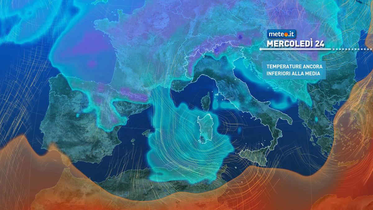
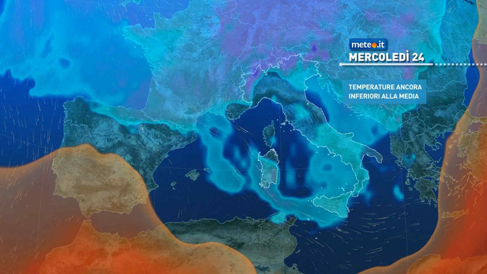
Al mattino cielo in generale nuvoloso con qualche apertura piu' ampia in Molise. Precipitazioni intermittenti possibili soprattutto in Toscana, Umbria, Marche e alto Lazio; quota neve intorno ai 1000-1200 metri sull'Appennino, anche piu' bassa nel nord della Toscana. Temperature minime stazionarie o in leggero calo. Nel pomeriggio aumento dell'instabilita' con possibile sviluppo di rovesci o temporali a carattere intermittente, meno probabili lungo le coste tirreniche. Neve oltre 800-1400 metri di quota. Alla sera parziale attenuazione dei fenomeni. Temperature massime in calo; valori inferiori alla norma. Un po' ventilato. Mari: poco mossi l'Adriatico e il Ligure orientale, mosso o molto mosso il Tirreno.

Notizie
TendenzaMeteo: ponte del 25 aprile molto variabile. Quando andrà via il freddo artico?
Meteo: ponte del 25 aprile molto variabile. Quando andrà via il freddo artico?
Colpo di coda invernale sull'Italia dove nella seconda parte di settimana si potrebbe vedere un graduale cambiamento. Ponte del 25 aprile incerto
Mediaset

Ultimo aggiornamento Martedì 23 Aprile ore 08:41

Copyright © 1999-2020 RTI S.p.A. Direzione Business Digital - P.Iva 03976881007 - Tutti i diritti riservati - Per la pubblicità Mediamond S.p.a. RTI spa, Gruppo Mediaset - Sede legale: 00187 Roma Largo del Nazareno 8 - Cap. Soc. € 500.000.007,00 int. vers. - Registro delle Imprese di Roma, C.F.06921720154